Kórnik night lights from space
Night Light of Kórnik (Greater Poland) from space (Poland) Src. Average luminocity for 10x10km area is 11.795% and for 50x50km: 16.527%.
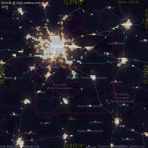
Analysis of Kórnik night lights 2016
Square area 10x10 km:
 0.26%
0.26%90-99
1.59%80-89
1.85%70-79
0.53%60-69
1.06%50-59
1.85%40-49
2.51%30-39
1.85%20-29
1.46%10-19
15.08%0-9
71.96%Square area 50x50 km:
4.54%90-99
4.07%80-89
1.26%70-79
1.33%60-69
1.37%50-59
1.83%40-49
1.55%30-39
2.48%20-29
3.32%10-19
5.84%0-9
72.4%Clear (daylight) street map image can be seen on geolist.org.
Map coordinates:
52° 40' 34" North, 16° 23' 10.9" East
52° 14' 51.8" North, 17° 5' 22.2" East
51° 48' 54.5" North, 17° 47' 33.4" East
Some cities around Kórnik sort by population:
• Poznań
20.8 km =12.9 mi,  328°
328°
• Śrem
18.4 km =11.4 mi,  196°
196°
• Swarzędz
18.4 km =11.4 mi,  359°
359°
• Luboń
17.4 km =10.8 mi,  309°
309°
• Środa Wielkopolska
12.9 km =8 mi,  99°
99°
• Mosina
16.5 km =10.3 mi,  269°
269°
• Puszczykowo
16.9 km =10.5 mi,  284°
284°
• Kostrzyn
19.2 km =11.9 mi,  29°
29°
3095194 (p: 7,206)
Sources (retrieved 2019-11-25):
» Earth at Night: Flat Maps 2012, 2016