Kolno night lights from space
Night Light of Kolno (Podlasie) from space (Poland) Src. Average luminocity for 10x10km area is 4.131% and for 50x50km: 0.9562%.
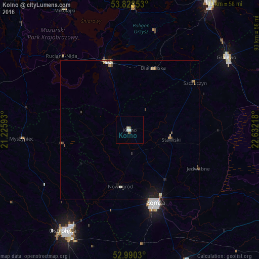
Analysis of Kolno night lights 2016
Square area 10x10 km:
100  0.93%
0.93%
90-99 1.06%
80-89 0.66%
70-79 0%
60-69 0.26%
50-59 0.79%
40-49 0.53%
30-39 0%
20-29 0%
10-19 0.53%
0-9 95.24%
0.93%90-99
1.06%80-89
0.66%70-79
0%60-69
0.26%50-59
0.79%40-49
0.53%30-39
0%20-29
0%10-19
0.53%0-9
95.24%Square area 50x50 km:
100 0.07%
90-99 0.16%
80-89 0.1%
70-79 0.07%
60-69 0.18%
50-59 0.13%
40-49 0.15%
30-39 0.07%
20-29 0.18%
10-19 0.69%
0-9 98.19%
0.07%90-99
0.16%80-89
0.1%70-79
0.07%60-69
0.18%50-59
0.13%40-49
0.15%30-39
0.07%20-29
0.18%10-19
0.69%0-9
98.19%Clear (daylight) street map image can be seen on geolist.org.
Map coordinates:
53° 49' 42.7" North, 21° 13' 33.3" East
53° 24' 41.3" North, 21° 55' 44.6" East
52° 59' 25.1" North, 22° 37' 55.8" East
Some cities around Kolno sort by population:
• Łomża
27.4 km =17 mi,  161°
161°
• Ełk
54.5 km =33.9 mi,  31°
31°
• Ostrołęka
43.1 km =26.8 mi,  213°
213°
• Zambrów
51.8 km =32.2 mi, 156°
• Grajewo
43.6 km =27.1 mi,  52°
52°
• Pisz
25.2 km =15.7 mi,  342°
342°
• Mońki
57.6 km =35.8 mi,  90°
90°
• Orzysz
44.3 km =27.5 mi,  1°
1°
768785 (p: 10,659)
Sources (retrieved 2019-11-25):
» Earth at Night: Flat Maps 2012, 2016