Jelcz night lights from space
Night Light of Jelcz (Lower Silesia) from space (Poland) Src. Average luminocity for 10x10km area is 11.016% and for 50x50km: 12.0407%.
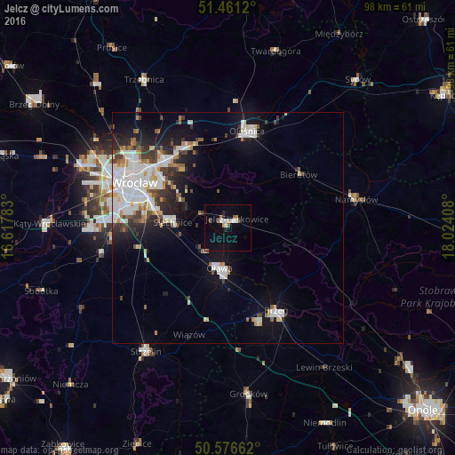
Analysis of Jelcz night lights 2016
Square area 10x10 km:
 2.01%
2.01%90-99
1.87%80-89
0.53%70-79
0.67%60-69
1.07%50-59
1.74%40-49
0.27%30-39
1.2%20-29
0.94%10-19
1.87%0-9
87.83%Square area 50x50 km:
3.33%90-99
2.79%80-89
0.89%70-79
0.79%60-69
1.04%50-59
0.95%40-49
1.17%30-39
1.36%20-29
2.56%10-19
6.37%0-9
78.72%Clear (daylight) street map image can be seen on geolist.org.
Map coordinates:
51° 27' 40.3" North, 16° 37' 4.2" East
51° 1' 15.7" North, 17° 19' 15.4" East
50° 34' 35.8" North, 18° 1' 26.7" East
Some cities around Jelcz sort by population:
• Oława
8.5 km =5.3 mi,  193°
193°
• Zgorzelisko
18.5 km =11.5 mi,  314°
314°
• Biskupin
17.5 km =10.9 mi,  300°
300°
• Sępolno
18.2 km =11.3 mi, 302°
• Księże Małe-Księże Wielkie
17.2 km =10.7 mi,  289°
289°
• Wojszyce
19.7 km =12.2 mi,  282°
282°
• Psie Pole Południe-Kiełczów
19.5 km =12.1 mi,  316°
316°
• Bierutów
19.5 km =12.1 mi,  53°
53°
3097271 (p: 15,308)
Sources (retrieved 2019-11-25):
» Earth at Night: Flat Maps 2012, 2016