Iłża night lights from space
Night Light of Iłża (Mazovia) from space (Poland) Src. Average luminocity for 10x10km area is 1.393% and for 50x50km: 4.5202%.
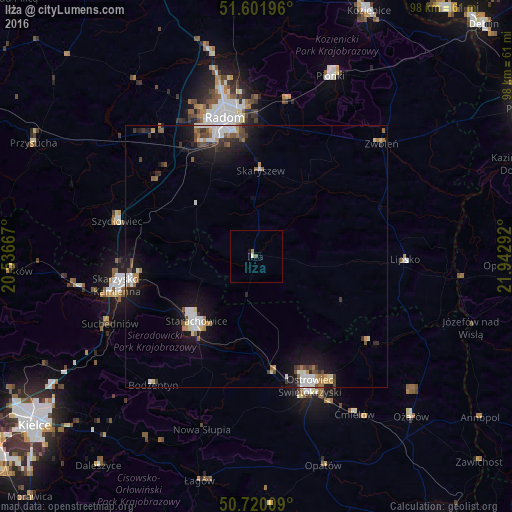
Analysis of Iłża night lights 2016
Square area 10x10 km:
 0%
0%90-99
0.53%80-89
0%70-79
0%60-69
0.53%50-59
0%40-49
0.53%30-39
0%20-29
0%10-19
0.53%0-9
97.86%Square area 50x50 km:
0.76%90-99
0.81%80-89
0.33%70-79
0.39%60-69
0.55%50-59
0.49%40-49
0.69%30-39
0.53%20-29
0.69%10-19
4.27%0-9
90.48%Clear (daylight) street map image can be seen on geolist.org.
Map coordinates:
51° 36' 7.1" North, 20° 32' 12" East
51° 9' 47.3" North, 21° 14' 23.2" East
50° 43' 12.3" North, 21° 56' 34.5" East
Some cities around Iłża sort by population:
• Radom
27.4 km =17 mi,  346°
346°
• Ostrowiec Świętokrzyski
27.9 km =17.3 mi,  158°
158°
• Starachowice
18.3 km =11.4 mi,  220°
220°
• Skarżysko-Kamienna
26.3 km =16.3 mi,  257°
257°
• Szydłowiec
27.4 km =17 mi,  285°
285°
• Suchedniów
31.4 km =19.5 mi,  245°
245°
• Zwoleń
32.3 km =20.1 mi,  48°
48°
• Lipsko
28.6 km =17.8 mi,  90°
90°
770792 (p: 5,121)
Sources (retrieved 2019-11-25):
» Earth at Night: Flat Maps 2012, 2016