Góra Kalwaria night lights from space
Night Light of Góra Kalwaria (Mazovia) from space (Poland) Src. Average luminocity for 10x10km area is 13.2146% and for 50x50km: 17.6238%.
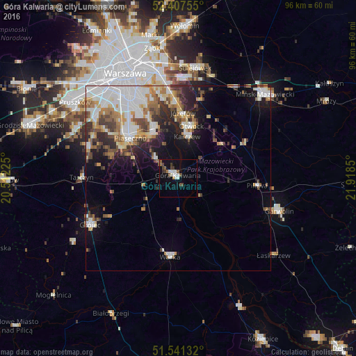
Analysis of Góra Kalwaria night lights 2016
Square area 10x10 km:
 2.15%
2.15%90-99
2.9%80-89
0%70-79
0.51%60-69
0.88%50-59
2.78%40-49
3.03%30-39
1.77%20-29
0.38%10-19
7.95%0-9
77.65%Square area 50x50 km:
4.46%90-99
3.65%80-89
1.65%70-79
1.72%60-69
2.33%50-59
2.11%40-49
2.08%30-39
2.26%20-29
3.2%10-19
6.67%0-9
69.88%Clear (daylight) street map image can be seen on geolist.org.
Map coordinates:
52° 24' 27.2" North, 20° 30' 44.1" East
51° 58' 35.5" North, 21° 12' 55.3" East
51° 32' 28.8" North, 21° 55' 6.6" East
Some cities around Góra Kalwaria sort by population:
• Ursynów
22.4 km =13.9 mi,  329°
329°
• Otwock
14.7 km =9.1 mi,  12°
12°
• Piaseczno
17.5 km =10.9 mi,  311°
311°
• Kabaty
19.4 km =12.1 mi, 331°
• Józefów
17.9 km =11.1 mi,  4°
4°
• Konstancin-Jeziorna
14.7 km =9.1 mi, 332°
• Warka
21.4 km =13.3 mi,  184°
184°
• Karczew
11.4 km =7.1 mi, 11°
771870 (p: 10,777)
Sources (retrieved 2019-11-25):
» Earth at Night: Flat Maps 2012, 2016