Warka night lights from space
Night Light of Warka (Mazovia) from space (Poland) Src. Average luminocity for 10x10km area is 7.2983% and for 50x50km: 2.9675%.
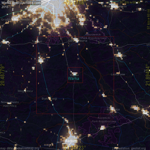
Analysis of Warka night lights 2016
Square area 10x10 km:
 1.96%
1.96%90-99
1.96%80-89
0%70-79
0.84%60-69
0.28%50-59
1.12%40-49
0.56%30-39
0%20-29
0%10-19
1.12%0-9
92.16%Square area 50x50 km:
0.45%90-99
0.49%80-89
0.18%70-79
0.32%60-69
0.34%50-59
0.41%40-49
0.49%30-39
0.36%20-29
0.13%10-19
1.42%0-9
95.42%Clear (daylight) street map image can be seen on geolist.org.
Map coordinates:
52° 13' 1.8" North, 20° 29' 16" East
51° 47' 3.5" North, 21° 11' 27.3" East
51° 20' 50" North, 21° 53' 38.5" East
Some cities around Warka sort by population:
• Piaseczno
35 km =21.7 mi,  340°
340°
• Kozienice
33.3 km =20.7 mi,  132°
132°
• Konstancin-Jeziorna
34.8 km =21.6 mi,  351°
351°
• Garwolin
31.7 km =19.7 mi,  66°
66°
• Grójec
23.9 km =14.9 mi,  291°
291°
• Góra Kalwaria
21.4 km =13.3 mi,  4°
4°
• Karczew
32.7 km =20.3 mi,  7°
7°
• Białobrzegi
22.5 km =14 mi,  227°
227°
756151 (p: 11,048)
Sources (retrieved 2019-11-25):
» Earth at Night: Flat Maps 2012, 2016