Głogówek night lights from space
Night Light of Głogówek (Opole Voivodeship) from space (Poland) Src. Average luminocity for 10x10km area is 2.1008% and for 50x50km: 2.8783%.
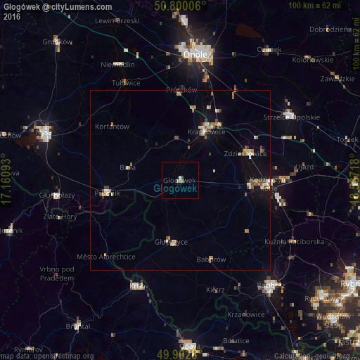
Analysis of Głogówek night lights 2016
Square area 10x10 km:
 0%
0%90-99
0.56%80-89
0%70-79
0.7%60-69
0.98%50-59
0%40-49
0.28%30-39
0.28%20-29
0%10-19
0%0-9
97.2%Square area 50x50 km:
0.2%90-99
0.51%80-89
0.23%70-79
0.37%60-69
0.54%50-59
0.48%40-49
0.47%30-39
0.2%20-29
0.14%10-19
1.62%0-9
95.23%Clear (daylight) street map image can be seen on geolist.org.
Map coordinates:
50° 48' 0.2" North, 17° 9' 39.3" East
50° 21' 12.8" North, 17° 51' 50.6" East
49° 54' 10.1" North, 18° 34' 1.8" East
Some cities around Głogówek sort by population:
• Kędzierzyn-Koźle
25.7 km =16 mi,  90°
90°
• Krnov, CZ
31.5 km =19.6 mi,  201°
201°
• Prudnik
20.9 km =13 mi,  260°
260°
• Krapkowice
15.3 km =9.5 mi,  27°
27°
• Koźle
19.9 km =12.4 mi,  95°
95°
• Głubczyce
17.2 km =10.7 mi,  188°
188°
• Zdzieszowice
20 km =12.4 mi,  66°
66°
• Gogolin
19 km =11.8 mi,  35°
35°
3099209 (p: 5,755)
Sources (retrieved 2019-11-25):
» Earth at Night: Flat Maps 2012, 2016