Brzeg Dolny night lights from space
Night Light of Brzeg Dolny (Lower Silesia) from space (Poland) Src. Average luminocity for 10x10km area is 12.7675% and for 50x50km: 9.2194%.
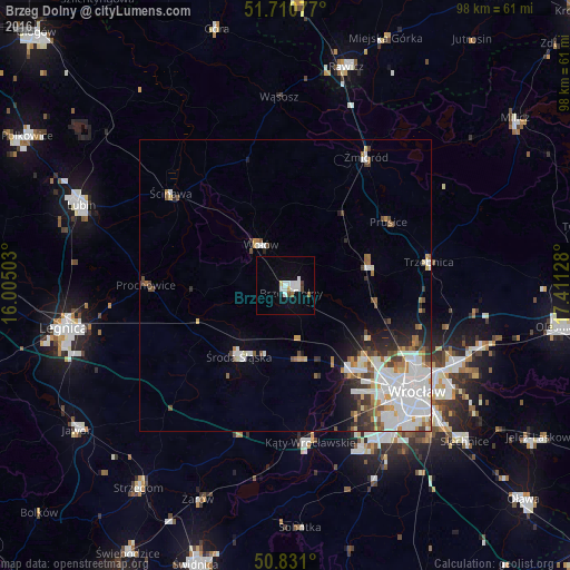
Analysis of Brzeg Dolny night lights 2016
Square area 10x10 km:
 3.36%
3.36%90-99
3.36%80-89
0.56%70-79
0.56%60-69
0.7%50-59
0.42%40-49
0.98%30-39
0.42%20-29
0.42%10-19
2.66%0-9
86.55%Square area 50x50 km:
2.89%90-99
2.28%80-89
0.53%70-79
0.78%60-69
0.84%50-59
0.87%40-49
1.03%30-39
0.87%20-29
1.36%10-19
2.21%0-9
86.34%Clear (daylight) street map image can be seen on geolist.org.
Map coordinates:
51° 42' 38.8" North, 16° 0' 18.1" East
51° 16' 22.8" North, 16° 42' 29.3" East
50° 49' 51.6" North, 17° 24' 40.6" East
Some cities around Brzeg Dolny sort by population:
• Stabłowice
18.8 km =11.7 mi,  134°
134°
• Wołów
8.3 km =5.2 mi,  327°
327°
• Środa Śląska
14.4 km =8.9 mi,  213°
213°
• Leśnica-Ratyń-Pustki
17.5 km =10.9 mi,  146°
146°
• Oborniki Śląskie
14.7 km =9.1 mi,  77°
77°
• Maślice Małe
21.3 km =13.2 mi, 130°
• Pilczyce
23 km =14.3 mi, 131°
• Złotniki
19.6 km =12.2 mi,  140°
140°
3102456 (p: 12,689)
Sources (retrieved 2019-11-25):
» Earth at Night: Flat Maps 2012, 2016