Blachownia night lights from space
Night Light of Blachownia (Silesia) from space (Poland) Src. Average luminocity for 10x10km area is 6.1737% and for 50x50km: 6.7153%.
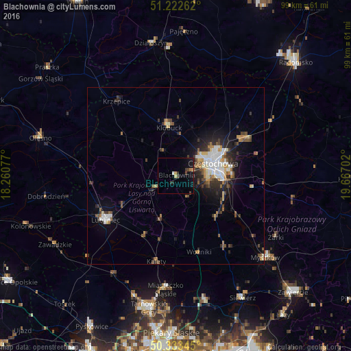
Analysis of Blachownia night lights 2016
Square area 10x10 km:
 0.28%
0.28%90-99
0.28%80-89
0.56%70-79
1.12%60-69
0.56%50-59
0%40-49
2.1%30-39
0.98%20-29
1.12%10-19
5.32%0-9
87.68%Square area 50x50 km:
1.15%90-99
1.13%80-89
0.65%70-79
0.62%60-69
0.8%50-59
0.82%40-49
1.11%30-39
1%20-29
1.87%10-19
3.63%0-9
87.23%Clear (daylight) street map image can be seen on geolist.org.
Map coordinates:
51° 13' 21.4" North, 18° 15' 38.8" East
50° 46' 48.5" North, 18° 57' 50" East
50° 20' 0.4" North, 19° 40' 1.3" East
Some cities around Blachownia sort by population:
• Częstochowa
11.4 km =7.1 mi,  80°
80°
• Tarnowskie Góry
37.9 km =23.5 mi,  190°
190°
• Myszków
34.1 km =21.2 mi,  131°
131°
• Lubliniec
23.2 km =14.4 mi,  237°
237°
• Kłobuck
13.6 km =8.5 mi,  351°
351°
• Kalety
24.7 km =15.3 mi, 191°
• Miasteczko Śląskie
30.9 km =19.2 mi,  183°
183°
• Działoszyn
38.1 km =23.7 mi, 349°
3103274 (p: 9,891)
Sources (retrieved 2019-11-25):
» Earth at Night: Flat Maps 2012, 2016