Kłobuck night lights from space
Night Light of Kłobuck (Silesia) from space (Poland) Src. Average luminocity for 10x10km area is 6.409% and for 50x50km: 5.9607%.
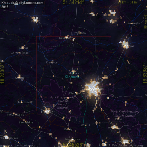
Analysis of Kłobuck night lights 2016
Square area 10x10 km:
 0%
0%90-99
0.7%80-89
1.4%70-79
0.42%60-69
0.84%50-59
1.82%40-49
1.54%30-39
1.68%20-29
0.56%10-19
0.56%0-9
90.48%Square area 50x50 km:
1.09%90-99
1.05%80-89
0.6%70-79
0.58%60-69
0.69%50-59
0.54%40-49
1%30-39
0.89%20-29
1.7%10-19
3.25%0-9
88.61%Clear (daylight) street map image can be seen on geolist.org.
Map coordinates:
51° 20' 31.7" North, 18° 14' 1" East
50° 54' 2.9" North, 18° 56' 12.3" East
50° 27' 18.9" North, 19° 38' 23.5" East
Some cities around Kłobuck sort by population:
• Częstochowa
17.5 km =10.9 mi,  131°
131°
• Lubliniec
31.3 km =19.4 mi,  214°
214°
• Olesno
36.3 km =22.6 mi,  265°
265°
• Blachownia
13.6 km =8.5 mi,  171°
171°
• Kalety
37.7 km =23.4 mi,  184°
184°
• Praszka
37.9 km =23.5 mi,  296°
296°
• Pajęczno
27.4 km =17 mi,  8°
8°
• Działoszyn
24.6 km =15.3 mi,  348°
348°
3096090 (p: 13,190)
Sources (retrieved 2019-11-25):
» Earth at Night: Flat Maps 2012, 2016