Strzelce Krajeńskie night lights from space
Night Light of Strzelce Krajeńskie (Lubusz) from space (Poland) Src. Average luminocity for 10x10km area is 2.6793% and for 50x50km: 2.531%.
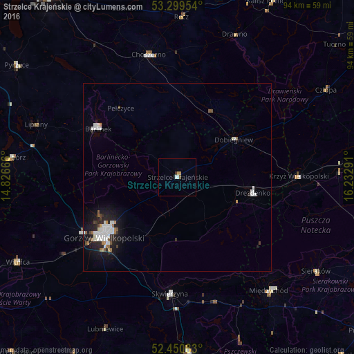
Analysis of Strzelce Krajeńskie night lights 2016
Square area 10x10 km:
 0.38%
0.38%90-99
0.63%80-89
0%70-79
1.01%60-69
0%50-59
0.25%40-49
0.25%30-39
0.51%20-29
0%10-19
0.51%0-9
96.46%Square area 50x50 km:
0.62%90-99
0.64%80-89
0.06%70-79
0.16%60-69
0.23%50-59
0.2%40-49
0.21%30-39
0.16%20-29
0.69%10-19
1.85%0-9
95.17%Clear (daylight) street map image can be seen on geolist.org.
Map coordinates:
53° 17' 58.3" North, 14° 49' 36" East
52° 52' 38.1" North, 15° 31' 47.2" East
52° 27' 3" North, 16° 13' 58.5" East
Some cities around Strzelce Krajeńskie sort by population:
• Gorzów Wielkopolski
25.6 km =15.9 mi,  232°
232°
• Choszczno
33.3 km =20.7 mi,  347°
347°
• Barlinek
24.6 km =15.3 mi,  302°
302°
• Międzychód
39.6 km =24.6 mi,  141°
141°
• Drezdenko
20.7 km =12.9 mi,  102°
102°
• Skwierzyna
31 km =19.3 mi,  182°
182°
• Krzyż Wielkopolski
32.3 km =20.1 mi,  89°
89°
• Wieleń
43.1 km =26.8 mi, 87°
3084421 (p: 9,978)
Sources (retrieved 2019-11-25):
» Earth at Night: Flat Maps 2012, 2016