Baffa night lights from space
Night Light of Baffa (Khyber Pakhtunkhwa) from space (Pakistan) Src. Average luminocity for 10x10km area is 4.1346% and for 50x50km: 4.3532%.
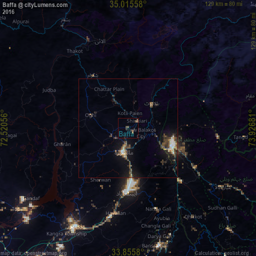
Analysis of Baffa night lights 2016
Square area 10x10 km:
 0%
0%90-99
0%80-89
0%70-79
0.52%60-69
0.17%50-59
1.4%40-49
2.8%30-39
0.87%20-29
1.57%10-19
0%0-9
92.66%Square area 50x50 km:
0.13%90-99
0.65%80-89
0.41%70-79
0.2%60-69
0.41%50-59
0.83%40-49
1.28%30-39
1.12%20-29
1.4%10-19
4.01%0-9
89.56%Clear (daylight) street map image can be seen on geolist.org.
Map coordinates:
35° 0' 56.1" North, 72° 31' 14" East
34° 26' 15.7" North, 73° 13' 25.2" East
33° 51' 20.9" North, 73° 55' 36.5" East
Some cities around Baffa sort by population:
• Muzaffarābād
23.9 km =14.9 mi,  108°
108°
• Battagram
32.3 km =20.1 mi,  325°
325°
• Abbottabad
32.4 km =20.1 mi,  181°
181°
• Mansehra
12.2 km =7.6 mi,  191°
191°
• Haripur
55.6 km =34.5 mi,  208°
208°
• Havelian
43.1 km =26.8 mi, 187°
• Khalabat
52 km =32.3 mi,  216°
216°
• Murree
60.8 km =37.8 mi,  165°
165°
1184020 (p: 14,047)
Sources (retrieved 2019-11-25):
» Earth at Night: Flat Maps 2012, 2016