Baddomalhi night lights from space
Night Light of Baddomalhi (Punjab) from space (Pakistan) Src. Average luminocity for 10x10km area is 1% and for 50x50km: 5.5376%.
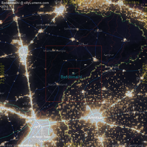
Analysis of Baddomalhi night lights 2016
Square area 10x10 km:
 0%
0%90-99
0%80-89
0%70-79
0%60-69
0%50-59
0.35%40-49
1.05%30-39
0%20-29
0%10-19
0%0-9
98.6%Square area 50x50 km:
0.02%90-99
0.3%80-89
0.23%70-79
0.23%60-69
0.49%50-59
1.15%40-49
2.74%30-39
1.69%20-29
1.77%10-19
5.09%0-9
86.28%Clear (daylight) street map image can be seen on geolist.org.
Map coordinates:
32° 35' 5.4" North, 73° 57' 39.5" East
31° 59' 25.5" North, 74° 39' 50.8" East
31° 23' 31.7" North, 75° 22' 2" East
Some cities around Baddomalhi sort by population:
• Narowal
23.3 km =14.5 mi,  57°
57°
• Pasrur
30.3 km =18.8 mi,  359°
359°
• Narang Mandi
17 km =10.6 mi,  235°
235°
• Ajnāla, IN
18.7 km =11.6 mi,  150°
150°
• Fatehgarh Chūriān, IN
31 km =19.3 mi,  116°
116°
• Rāja Sānsi, IN
32.7 km =20.3 mi,  156°
156°
• Kalaswala
23.4 km =14.5 mi, 356°
• Rām Dās, IN
23.2 km =14.4 mi,  96°
96°
1184075 (p: 18,435)
Sources (retrieved 2019-11-25):
» Earth at Night: Flat Maps 2012, 2016