Narang Mandi night lights from space
Night Light of Narang Mandi (Punjab) from space (Pakistan) Src. Average luminocity for 10x10km area is 2.859% and for 50x50km: 8.5149%.
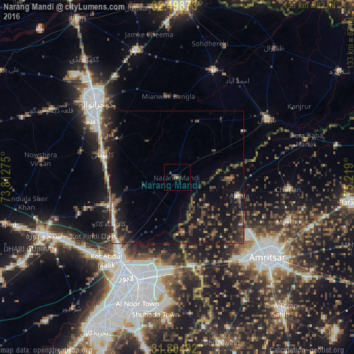

Analysis of Narang Mandi night lights 2016
Square area 10x10 km:
 0%
0%90-99
0%80-89
0%70-79
0%60-69
0.73%50-59
0.37%40-49
2.01%30-39
2.01%20-29
0.73%10-19
0%0-9
94.14%Square area 50x50 km:
0.18%90-99
0.82%80-89
0.29%70-79
0.47%60-69
1.1%50-59
1.49%40-49
3.15%30-39
2.67%20-29
3.1%10-19
11.01%0-9
75.72%Clear (daylight) street map image can be seen on geolist.org.
Map coordinates:
32° 29' 55.4" North, 73° 48' 45.9" East
31° 54' 13.5" North, 74° 30' 57.1" East
31° 18' 17.7" North, 75° 13' 8.4" East
Some cities around Narang Mandi sort by population:
• Kamoke
28.8 km =17.9 mi,  286°
286°
• Muridke
26.9 km =16.7 mi,  245°
245°
• Eminabad
28.6 km =17.8 mi,  302°
302°
• Ajnāla, IN
24.2 km =15 mi,  105°
105°
• Baddomalhi
17 km =10.6 mi,  55°
55°
• Rāja Sānsi, IN
33.8 km =21 mi,  127°
127°
• Kalaswala
35.3 km =21.9 mi,  20°
20°
• Rām Dās, IN
37.7 km =23.4 mi,  79°
79°
1169334 (p: 34,778)
Sources (retrieved 2019-11-25):
» Earth at Night: Flat Maps 2012, 2016