Rām Dās night lights from space
Night Light of Rām Dās (Punjab) from space (India) Src. Average luminocity for 10x10km area is 4.7657% and for 50x50km: 10.9%.
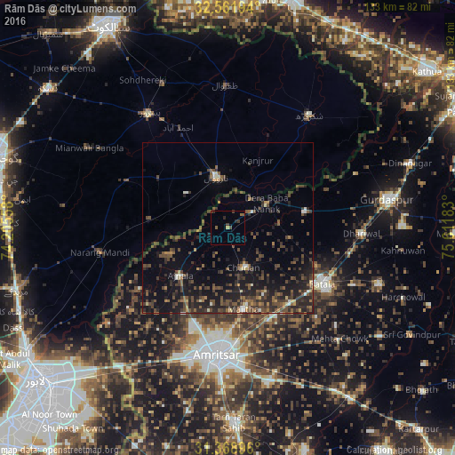
Analysis of Rām Dās night lights 2016
Square area 10x10 km:
 0%
0%90-99
0%80-89
0%70-79
0.7%60-69
0.52%50-59
1.57%40-49
1.4%30-39
2.1%20-29
2.1%10-19
0%0-9
91.61%Square area 50x50 km:
0.25%90-99
0.72%80-89
0.56%70-79
0.74%60-69
1.11%50-59
2.23%40-49
4.43%30-39
3.62%20-29
5.01%10-19
8.81%0-9
72.53%Clear (daylight) street map image can be seen on geolist.org.
Map coordinates:
32° 33' 43" North, 74° 12' 20.1" East
31° 58' 2.6" North, 74° 54' 31.3" East
31° 22' 8.3" North, 75° 36' 42.6" East
Some cities around Rām Dās sort by population:
• Narowal, PK
15.3 km =9.5 mi,  347°
347°
• Fazilpur, PK
27.5 km =17.1 mi,  32°
32°
• Ajnāla
19.4 km =12.1 mi,  225°
225°
• Baddomalhi, PK
23.2 km =14.4 mi,  276°
276°
• Fatehgarh Chūriān
12.3 km =7.6 mi,  158°
158°
• Majītha
23.9 km =14.9 mi,  168°
168°
• Kalanaur
23.4 km =14.5 mi,  77°
77°
• Derā Nānak
13.7 km =8.5 mi,  55°
55°
1258708 (p: 6,190)
Sources (retrieved 2019-11-25):
» Earth at Night: Flat Maps 2012, 2016