Wañgan night lights from space
Night Light of Wañgan (Davao) from space (Philippines) Src. Average luminocity for 10x10km area is 10.5671% and for 50x50km: 12.3692%.
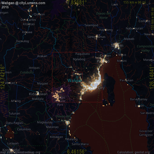
Analysis of Wañgan night lights 2016
Square area 10x10 km:
100  0%
0%
90-99 0%
80-89 0%
70-79 0.87%
60-69 1.95%
50-59 4.98%
40-49 1.52%
30-39 3.9%
20-29 5.63%
10-19 3.9%
0-9 77.27%
0%90-99
0%80-89
0%70-79
0.87%60-69
1.95%50-59
4.98%40-49
1.52%30-39
3.9%20-29
5.63%10-19
3.9%0-9
77.27%Square area 50x50 km:
100 2.04%
90-99 1.64%
80-89 1.11%
70-79 1.77%
60-69 1.96%
50-59 1.73%
40-49 1.42%
30-39 2.28%
20-29 3.63%
10-19 8%
0-9 74.43%
2.04%90-99
1.64%80-89
1.11%70-79
1.77%60-69
1.96%50-59
1.73%40-49
1.42%30-39
2.28%20-29
3.63%10-19
8%0-9
74.43%Clear (daylight) street map image can be seen on geolist.org.
Map coordinates:
7° 51' 24.5" North, 124° 44' 31.8" East
7° 9' 35" North, 125° 26' 43" East
6° 27' 41.6" North, 126° 8' 54.3" East
Some cities around Wañgan sort by population:
• Davao
20.8 km =12.9 mi,  117°
117°
• Biao
8.4 km =5.2 mi,  87°
87°
• Tamugan
11 km =6.8 mi,  316°
316°
• Baracatan
21.6 km =13.4 mi,  188°
188°
• Tamayong
7.8 km =4.8 mi,  247°
247°
• Inawayan
22.3 km =13.9 mi,  172°
172°
• Bato
13.3 km =8.3 mi, 166°
• Sirib
5.1 km =3.2 mi,  235°
235°
1679689 (p: 7,621)
Sources (retrieved 2019-11-25):
» Earth at Night: Flat Maps 2012, 2016