Bato night lights from space
Night Light of Bato (Davao) from space (Philippines) Src. Average luminocity for 10x10km area is 30.6602% and for 50x50km: 12.1083%.
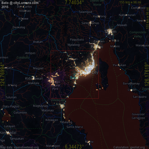
Analysis of Bato night lights 2016
Square area 10x10 km:
100  3.25%
3.25%
90-99 1.95%
80-89 3.9%
70-79 4.76%
60-69 8.44%
50-59 6.93%
40-49 3.03%
30-39 3.03%
20-29 9.09%
10-19 25.32%
0-9 30.3%
3.25%90-99
1.95%80-89
3.9%70-79
4.76%60-69
8.44%50-59
6.93%40-49
3.03%30-39
3.03%20-29
9.09%10-19
25.32%0-9
30.3%Square area 50x50 km:
100 2.04%
90-99 1.62%
80-89 0.93%
70-79 1.75%
60-69 1.91%
50-59 1.65%
40-49 1.33%
30-39 2.2%
20-29 3.84%
10-19 8.2%
0-9 74.52%
2.04%90-99
1.62%80-89
0.93%70-79
1.75%60-69
1.91%50-59
1.65%40-49
1.33%30-39
2.2%20-29
3.84%10-19
8.2%0-9
74.52%Clear (daylight) street map image can be seen on geolist.org.
Map coordinates:
7° 44' 25.2" North, 124° 46' 11.8" East
7° 2' 35" North, 125° 28' 23" East
6° 20' 41" North, 126° 10' 34.3" East
Some cities around Bato sort by population:
• Biao
14.4 km =8.9 mi,  21°
21°
• Astorga
15.2 km =9.4 mi,  187°
187°
• Sibulan
12.2 km =7.6 mi, 185°
• Wañgan
13.3 km =8.3 mi,  346°
346°
• Baracatan
10.5 km =6.5 mi,  216°
216°
• Tamayong
14.4 km =8.9 mi,  314°
314°
• Inawayan
9.1 km =5.7 mi,  179°
179°
• Sirib
12.4 km =7.7 mi,  324°
324°
1726183 (p: 5,008)
Sources (retrieved 2019-11-25):
» Earth at Night: Flat Maps 2012, 2016