Taysan night lights from space
Night Light of Taysan (Calabarzon) from space (Philippines) Src. Average luminocity for 10x10km area is 11.6756% and for 50x50km: 11.8285%.
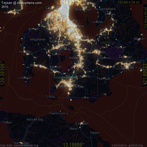
Analysis of Taysan night lights 2016
Square area 10x10 km:
 0%
0%90-99
0%80-89
0%70-79
0.83%60-69
1.24%50-59
1.24%40-49
4.96%30-39
2.48%20-29
1.65%10-19
21.49%0-9
66.12%Square area 50x50 km:
0.5%90-99
0.64%80-89
0.71%70-79
3.36%60-69
2.3%50-59
0.97%40-49
2.48%30-39
2.71%20-29
2.91%10-19
10.99%0-9
72.44%Clear (daylight) street map image can be seen on geolist.org.
Map coordinates:
14° 33' 4.7" North, 120° 23' 38.3" East
13° 52' 10.9" North, 121° 5' 49.6" East
13° 11' 9.9" North, 121° 48' 0.8" East
Some cities around Taysan sort by population:
• Lipa City
10.7 km =6.6 mi,  41°
41°
• Banaybanay
11.3 km =7 mi,  101°
101°
• San Pascual
10.4 km =6.5 mi,  230°
230°
• Bauan
12.9 km =8 mi, 227°
• Cuenca
6 km =3.7 mi,  306°
306°
• Santa Rita Aplaya
12.8 km =8 mi,  211°
211°
• Ibaan
7 km =4.3 mi,  146°
146°
• Banaybanay
7.3 km =4.5 mi,  15°
15°
1682618 (p: 5,296)
Sources (retrieved 2019-11-25):
» Earth at Night: Flat Maps 2012, 2016