Ibaan night lights from space
Night Light of Ibaan (Calabarzon) from space (Philippines) Src. Average luminocity for 10x10km area is 8.7707% and for 50x50km: 9.5577%.
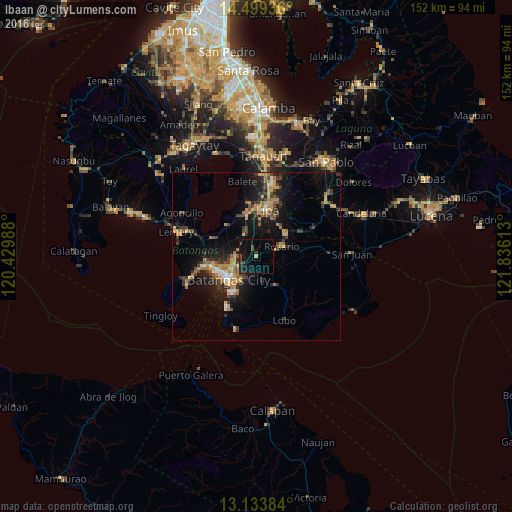
Analysis of Ibaan night lights 2016
Square area 10x10 km:
 0%
0%90-99
0%80-89
0.21%70-79
0.62%60-69
0%50-59
0%40-49
4.96%30-39
1.24%20-29
3.1%10-19
15.5%0-9
74.38%Square area 50x50 km:
0.47%90-99
0.6%80-89
0.51%70-79
2.63%60-69
1.86%50-59
0.75%40-49
1.93%30-39
2.17%20-29
2.22%10-19
8.61%0-9
78.24%Clear (daylight) street map image can be seen on geolist.org.
Map coordinates:
14° 29' 57.7" North, 120° 25' 47.6" East
13° 49' 3.4" North, 121° 7' 58.8" East
13° 8' 1.8" North, 121° 50' 10.1" East
Some cities around Ibaan sort by population:
• Batangas
10.5 km =6.5 mi,  229°
229°
• Banaybanay
8.1 km =5 mi,  63°
63°
• San Pascual
12 km =7.5 mi,  266°
266°
• Cuenca
12.8 km =8 mi,  317°
317°
• Santa Rita Aplaya
11.8 km =7.3 mi,  244°
244°
• Banaybanay
13 km =8.1 mi,  351°
351°
• Quilo-quilo
10.8 km =6.7 mi, 61°
• Taysan
7 km =4.3 mi,  326°
326°
1711431 (p: 9,430)
Sources (retrieved 2019-11-25):
» Earth at Night: Flat Maps 2012, 2016