Tampakan night lights from space
Night Light of Tampakan (Soccsksargen) from space (Philippines) Src. Average luminocity for 10x10km area is 0% and for 50x50km: 0.2792%.
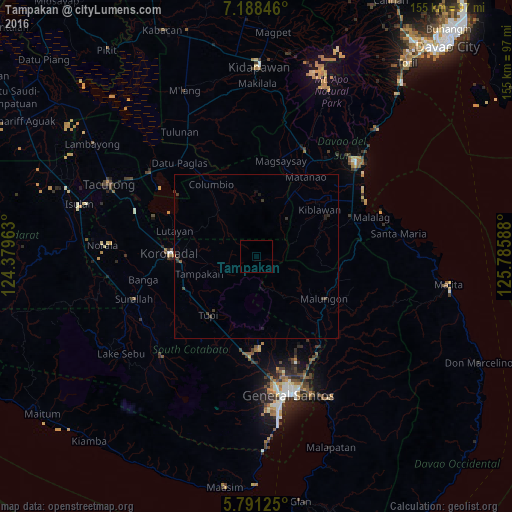
Analysis of Tampakan night lights 2016
Square area 10x10 km:
 0%
0%90-99
0%80-89
0%70-79
0%60-69
0%50-59
0%40-49
0%30-39
0%20-29
0%10-19
0%0-9
100%Square area 50x50 km:
0%90-99
0%80-89
0%70-79
0.01%60-69
0.01%50-59
0.03%40-49
0.16%30-39
0.22%20-29
0.18%10-19
0.05%0-9
99.33%Clear (daylight) street map image can be seen on geolist.org.
Map coordinates:
7° 11' 18.5" North, 124° 22' 46.7" East
6° 29' 25.2" North, 125° 4' 57.9" East
5° 47' 28.5" North, 125° 47' 9.2" East
Some cities around Tampakan sort by population:
• Koronadal
26.1 km =16.2 mi,  273°
273°
• Tupi
22.5 km =14 mi,  219°
219°
• Lambayong
5.3 km =3.3 mi,  307°
307°
• Polonoling
26.1 km =16.2 mi,  208°
208°
• Tamnag
24.2 km =15 mi,  292°
292°
• Cebuano
17 km =10.6 mi,  227°
227°
• Carpenter Hill
22.8 km =14.2 mi,  256°
256°
• Kipalbig
19.4 km =12.1 mi,  242°
242°
1683430 (p: 9,048)
Sources (retrieved 2019-11-25):
» Earth at Night: Flat Maps 2012, 2016