Santa Lucia night lights from space
Night Light of Santa Lucia (Central Luzon) from space (Philippines) Src. Average luminocity for 10x10km area is 1.1212% and for 50x50km: 9.5129%.
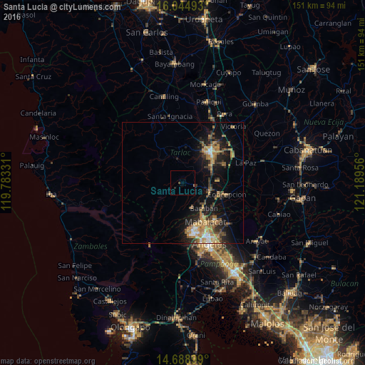
Analysis of Santa Lucia night lights 2016
Square area 10x10 km:
 0%
0%90-99
0%80-89
0%70-79
0%60-69
0.22%50-59
1.08%40-49
0%30-39
0%20-29
0.87%10-19
0%0-9
97.84%Square area 50x50 km:
0.49%90-99
0.78%80-89
0.98%70-79
2.17%60-69
2.39%50-59
1.23%40-49
1.54%30-39
1.58%20-29
2.64%10-19
6.83%0-9
79.38%Clear (daylight) street map image can be seen on geolist.org.
Map coordinates:
16° 2' 41.7" North, 119° 46' 59.9" East
15° 22' 5" North, 120° 29' 11.1" East
14° 41' 20.4" North, 121° 11' 22.4" East
Some cities around Santa Lucia sort by population:
• Mabalacat City
18.5 km =11.5 mi,  150°
150°
• Tarlac City
17.3 km =10.7 mi,  43°
43°
• Capas
11.8 km =7.3 mi,  110°
110°
• Concepcion
18.9 km =11.7 mi,  104°
104°
• San Miguel
14.7 km =9.1 mi,  55°
55°
• Cut-cut Primero
16.6 km =10.3 mi, 39°
• Mapalacsiao
19 km =11.8 mi,  69°
69°
• Murcia
13.7 km =8.5 mi, 72°
1688090 (p: 8,642)
Sources (retrieved 2019-11-25):
» Earth at Night: Flat Maps 2012, 2016