Guagua night lights from space
Night Light of Guagua (Central Luzon) from space (Philippines) Src. Average luminocity for 10x10km area is 15.1632% and for 50x50km: 16.1939%.
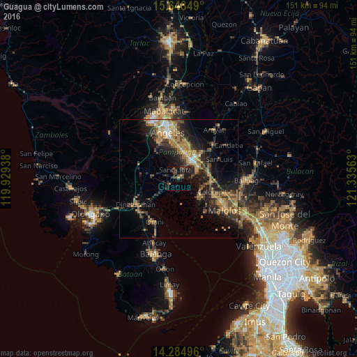
Analysis of Guagua night lights 2016
Square area 10x10 km:
 0%
0%90-99
0%80-89
0%70-79
1.45%60-69
1.03%50-59
2.07%40-49
6.61%30-39
7.44%20-29
10.74%10-19
15.5%0-9
55.17%Square area 50x50 km:
0.76%90-99
1.03%80-89
1.15%70-79
4.34%60-69
3.89%50-59
1.76%40-49
3.65%30-39
3.63%20-29
5.25%10-19
10.42%0-9
64.12%Clear (daylight) street map image can be seen on geolist.org.
Map coordinates:
15° 38' 36.6" North, 119° 55' 45.8" East
14° 57' 55.1" North, 120° 37' 57" East
14° 17' 5.9" North, 121° 20' 8.3" East
Some cities around Guagua sort by population:
• Lubao
4.4 km =2.7 mi,  230°
230°
• Sexmoan
2.6 km =1.6 mi,  203°
203°
• Santa Cruz
9.2 km =5.7 mi, 230°
• Minalin
5.4 km =3.4 mi,  87°
87°
• Lourdes
5.5 km =3.4 mi, 88°
• San Roque Dau First
6.1 km =3.8 mi,  282°
282°
• Pulungmasle
8.9 km =5.5 mi,  295°
295°
• San Basilio
9.2 km =5.7 mi,  325°
325°
1712627 (p: 9,519)
Sources (retrieved 2019-11-25):
» Earth at Night: Flat Maps 2012, 2016