Pototan night lights from space
Night Light of Pototan (Western Visayas) from space (Philippines) Src. Average luminocity for 10x10km area is 1.4134% and for 50x50km: 3.2456%.
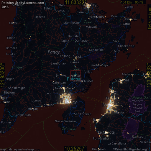
Analysis of Pototan night lights 2016
Square area 10x10 km:
 0%
0%90-99
0%80-89
0%70-79
0%60-69
0.87%50-59
0%40-49
0%30-39
1.3%20-29
1.3%10-19
0%0-9
96.54%Square area 50x50 km:
0.07%90-99
0.04%80-89
0.87%70-79
0.91%60-69
0.42%50-59
0.23%40-49
0.67%30-39
0.59%20-29
0.93%10-19
2.39%0-9
92.88%Clear (daylight) street map image can be seen on geolist.org.
Map coordinates:
11° 37' 59.6" North, 121° 55' 55.5" East
10° 56' 37.3" North, 122° 38' 6.7" East
10° 15' 9.3" North, 123° 20' 18" East
Some cities around Pototan sort by population:
• Passi
18.3 km =11.4 mi,  2°
2°
• Janiuay
14.1 km =8.8 mi,  272°
272°
• Barotac Nuevo
9.4 km =5.8 mi,  126°
126°
• Dumangas
15.7 km =9.8 mi,  147°
147°
• Santa Barbara
17.3 km =10.7 mi,  219°
219°
• Dingle
7.3 km =4.5 mi,  32°
32°
• Cabatuan
17.8 km =11.1 mi,  246°
246°
• Tumcon Ilawod
4.6 km =2.9 mi, 131°
1692817 (p: 10,195)
Sources (retrieved 2019-11-25):
» Earth at Night: Flat Maps 2012, 2016