Pasong Kawayan Primero night lights from space
Night Light of Pasong Kawayan Primero (Calabarzon) from space (Philippines) Src. Average luminocity for 10x10km area is 51.1948% and for 50x50km: 32.3491%.
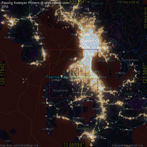
Analysis of Pasong Kawayan Primero night lights 2016
Square area 10x10 km:
 0.22%
0.22%90-99
1.52%80-89
2.38%70-79
13.42%60-69
22.73%50-59
11.47%40-49
21.43%30-39
11.47%20-29
9.52%10-19
5.84%0-9
0%Square area 50x50 km:
6.8%90-99
5.77%80-89
3.67%70-79
7.9%60-69
5.26%50-59
2.49%40-49
3.77%30-39
4.21%20-29
5.77%10-19
8.4%0-9
45.96%Clear (daylight) street map image can be seen on geolist.org.
Map coordinates:
15° 1' 24" North, 120° 10' 42.4" East
14° 20' 35.4" North, 120° 52' 53.7" East
13° 39' 39.4" North, 121° 35' 4.9" East
Some cities around Pasong Kawayan Primero sort by population:
• Dasmariñas
6.1 km =3.8 mi,  104°
104°
• Imus
11.3 km =7 mi,  31°
31°
• General Trias
4.9 km =3 mi,  0°
0°
• Noveleta
9.6 km =6 mi,  358°
358°
• Manggahan
6.1 km =3.8 mi,  159°
159°
• Halayhay
8.1 km =5 mi,  294°
294°
• Palangue
10 km =6.2 mi,  229°
229°
• Paradahan
3.3 km =2.1 mi,  222°
222°
1694514 (p: 7,031)
Sources (retrieved 2019-11-25):
» Earth at Night: Flat Maps 2012, 2016