Palangue night lights from space
Night Light of Palangue (Calabarzon) from space (Philippines) Src. Average luminocity for 10x10km area is 9.961% and for 50x50km: 22.4139%.
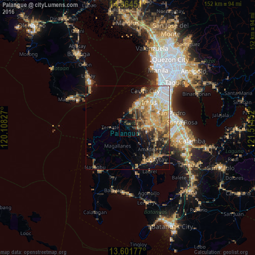
Analysis of Palangue night lights 2016
Square area 10x10 km:
 0%
0%90-99
0%80-89
0%70-79
0.87%60-69
0.65%50-59
1.3%40-49
4.55%30-39
3.25%20-29
3.68%10-19
17.53%0-9
68.18%Square area 50x50 km:
2.71%90-99
3.15%80-89
2.67%70-79
6.48%60-69
4.99%50-59
2.39%40-49
3.15%30-39
2.57%20-29
3.65%10-19
8.58%0-9
59.65%Clear (daylight) street map image can be seen on geolist.org.
Map coordinates:
14° 57' 52.2" North, 120° 6' 29.8" East
14° 17' 3" North, 120° 48' 41" East
13° 36' 6.4" North, 121° 30' 52.3" East
Some cities around Palangue sort by population:
• Naic
6.2 km =3.9 mi,  307°
307°
• Maragondon
8 km =5 mi,  261°
261°
• Ternate
10.2 km =6.3 mi,  273°
273°
• Manggahan
9.7 km =6 mi,  84°
84°
• Halayhay
10 km =6.2 mi,  1°
1°
• Paradahan
6.7 km =4.2 mi,  52°
52°
• Pasong Kawayan Primero
10 km =6.2 mi, 49°
• Pantijan No 2
5.8 km =3.6 mi,  191°
191°
1696261 (p: 9,567)
Sources (retrieved 2019-11-25):
» Earth at Night: Flat Maps 2012, 2016