Pantay Na Matanda night lights from space
Night Light of Pantay Na Matanda (Calabarzon) from space (Philippines) Src. Average luminocity for 10x10km area is 47.7684% and for 50x50km: 26.6006%.
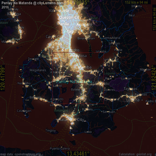
Analysis of Pantay Na Matanda night lights 2016
Square area 10x10 km:
 3.46%
3.46%90-99
3.46%80-89
6.28%70-79
16.88%60-69
9.52%50-59
3.46%40-49
11.26%30-39
9.52%20-29
17.1%10-19
15.37%0-9
3.68%Square area 50x50 km:
1.87%90-99
2.67%80-89
2.9%70-79
8.72%60-69
5.71%50-59
2.73%40-49
4.11%30-39
3.98%20-29
6.2%10-19
15.33%0-9
45.78%Clear (daylight) street map image can be seen on geolist.org.
Map coordinates:
14° 47' 54.1" North, 120° 25' 4.8" East
14° 7' 3" North, 121° 7' 16" East
13° 26' 4.6" North, 121° 49' 27.3" East
Some cities around Pantay Na Matanda sort by population:
• Tanauan
4.6 km =2.9 mi,  138°
138°
• Santo Tomas
2.4 km =1.5 mi,  116°
116°
• Malvar
9 km =5.6 mi,  153°
153°
• Bilog-Bilog
3.5 km =2.2 mi,  262°
262°
• Ambulong
7.2 km =4.5 mi,  243°
243°
• Balele
6.5 km =4 mi,  207°
207°
• Bitin
10.9 km =6.8 mi,  90°
90°
• Janopol
4.5 km =2.8 mi,  218°
218°
1694941 (p: 5,791)
Sources (retrieved 2019-11-25):
» Earth at Night: Flat Maps 2012, 2016