Ocaña night lights from space
Night Light of Ocaña (Central Visayas) from space (Philippines) Src. Average luminocity for 10x10km area is 4.9649% and for 50x50km: 3.2558%.
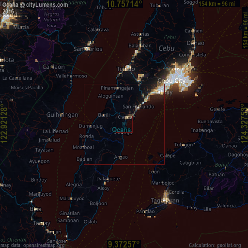
Analysis of Ocaña night lights 2016
Square area 10x10 km:
 0%
0%90-99
0%80-89
1.24%70-79
0.41%60-69
1.65%50-59
0%40-49
1.86%30-39
2.07%20-29
1.86%10-19
0%0-9
90.91%Square area 50x50 km:
0.45%90-99
0.43%80-89
0.27%70-79
0.39%60-69
0.56%50-59
0.19%40-49
0.72%30-39
0.66%20-29
0.82%10-19
2.29%0-9
93.22%Clear (daylight) street map image can be seen on geolist.org.
Map coordinates:
10° 45' 25.7" North, 122° 55' 16.6" East
10° 3' 56.2" North, 123° 37' 27.8" East
9° 22' 21.3" North, 124° 19' 39.1" East
Some cities around Ocaña sort by population:
• Carcar
4.8 km =3 mi,  21°
21°
• San Fernando
14.1 km =8.8 mi,  40°
40°
• Sibonga
5.5 km =3.4 mi,  188°
188°
• Guadalupe
6 km =3.7 mi,  341°
341°
• Perrelos
7.9 km =4.9 mi, 43°
• Barili
13.6 km =8.5 mi,  293°
293°
• Can-asujan
8 km =5 mi,  26°
26°
• Valencia
7.9 km =4.9 mi,  350°
350°
1697331 (p: 13,898)
Sources (retrieved 2019-11-25):
» Earth at Night: Flat Maps 2012, 2016