Mabini night lights from space
Night Light of Mabini (Central Luzon) from space (Philippines) Src. Average luminocity for 10x10km area is 0.2965% and for 50x50km: 2.6903%.
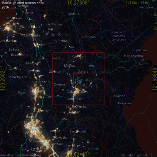
Analysis of Mabini night lights 2016
Square area 10x10 km:
 0%
0%90-99
0%80-89
0%70-79
0%60-69
0%50-59
0%40-49
0%30-39
0%20-29
0%10-19
0%0-9
100%Square area 50x50 km:
0%90-99
0.03%80-89
0.2%70-79
0.76%60-69
0.44%50-59
0.29%40-49
0.83%30-39
0.8%20-29
0.48%10-19
1.86%0-9
94.31%Clear (daylight) street map image can be seen on geolist.org.
Map coordinates:
16° 16' 33.9" North, 120° 16' 48.8" East
15° 36' 0" North, 120° 58' 60" East
14° 55' 18" North, 121° 41' 11.3" East
Some cities around Mabini sort by population:
• Cabanatuan City
12.8 km =8 mi,  188°
188°
• Talavera
7 km =4.3 mi,  259°
259°
• Muñoz
15.5 km =9.6 mi,  326°
326°
• Palayan City
12.7 km =7.9 mi,  120°
120°
• General Mamerto Natividad
7.3 km =4.5 mi,  87°
87°
• Baloc
11.6 km =7.2 mi,  294°
294°
• Santo Rosario
14 km =8.7 mi, 290°
• Llanera
8 km =5 mi,  27°
27°
1704552 (p: 7,810)
Sources (retrieved 2019-11-25):
» Earth at Night: Flat Maps 2012, 2016