Lourdes night lights from space
Night Light of Lourdes (Central Luzon) from space (Philippines) Src. Average luminocity for 10x10km area is 23.1012% and for 50x50km: 18.648%.
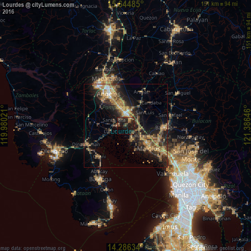
Analysis of Lourdes night lights 2016
Square area 10x10 km:
 0.83%
0.83%90-99
0%80-89
0.62%70-79
4.13%60-69
2.07%50-59
2.89%40-49
8.68%30-39
6.82%20-29
15.91%10-19
29.55%0-9
28.51%Square area 50x50 km:
0.77%90-99
1.08%80-89
1.36%70-79
5.13%60-69
4.85%50-59
2.12%40-49
4.22%30-39
4.13%20-29
6.18%10-19
11.69%0-9
58.48%Clear (daylight) street map image can be seen on geolist.org.
Map coordinates:
15° 38' 41.5" North, 119° 58' 48.8" East
14° 58' 0" North, 120° 40' 60" East
14° 17' 10.8" North, 121° 23' 11.3" East
Some cities around Lourdes sort by population:
• San Fernando
7.5 km =4.7 mi,  0°
0°
• Masantol
8.3 km =5.2 mi,  160°
160°
• Del Pilar
7.9 km =4.9 mi,  12°
12°
• Sexmoan
7 km =4.3 mi,  248°
248°
• Minalin
0.1 km =0.1 mi,  331°
331°
• Guagua
5.5 km =3.4 mi,  268°
268°
• San Vicente
7.4 km =4.6 mi,  108°
108°
• Santo Domingo
7 km =4.3 mi,  67°
67°
1705505 (p: 11,155)
Sources (retrieved 2019-11-25):
» Earth at Night: Flat Maps 2012, 2016