Guyong night lights from space
Night Light of Guyong (Central Luzon) from space (Philippines) Src. Average luminocity for 10x10km area is 50.0744% and for 50x50km: 29.6119%.

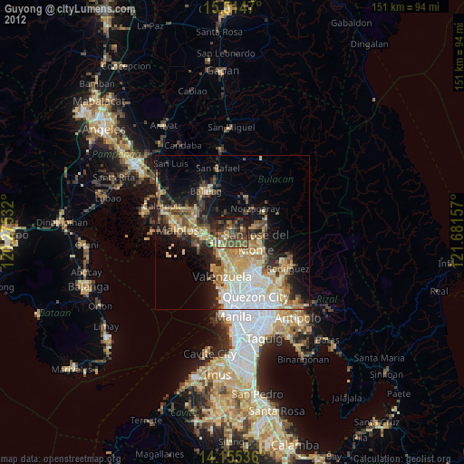


Analysis of Guyong night lights 2016
Square area 10x10 km:
 0.83%
0.83%90-99
0.83%80-89
2.69%70-79
11.78%60-69
16.53%50-59
19.83%40-49
20.04%30-39
11.57%20-29
8.47%10-19
7.44%0-9
0%Square area 50x50 km:
6%90-99
3.87%80-89
2.87%70-79
6.29%60-69
6.66%50-59
2.93%40-49
3.72%30-39
4.22%20-29
6.13%10-19
10.86%0-9
46.45%Clear (daylight) street map image can be seen on geolist.org.
Map coordinates:
15° 30' 52.9" North, 120° 16' 31.2" East
14° 50' 10" North, 120° 58' 42.4" East
14° 9' 19.3" North, 121° 40' 53.7" East
Some cities around Guyong sort by population:
• San Jose del Monte
7.6 km =4.7 mi,  108°
108°
• Meycauayan
11.2 km =7 mi,  189°
189°
• Bocaue
7 km =4.3 mi,  233°
233°
• Marilao
9.3 km =5.8 mi,  200°
200°
• Guiguinto
10.2 km =6.3 mi,  268°
268°
• Pandi
3.9 km =2.4 mi,  324°
324°
• Loma de Gato
5.7 km =3.5 mi,  157°
157°
• Sulucan
7.3 km =4.5 mi, 230°
1712051 (p: 155,391)
Sources (retrieved 2019-11-25):
» NASA, Earths city lights 1995
» NASA city lights 2003
» Earth at Night: Flat Maps 2012, 2016