Catmon night lights from space
Night Light of Catmon (Central Visayas) from space (Philippines) Src. Average luminocity for 10x10km area is 0.3719% and for 50x50km: 0.6159%.
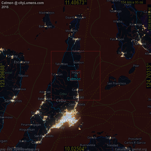
Analysis of Catmon night lights 2016
Square area 10x10 km:
 0%
0%90-99
0%80-89
0%70-79
0%60-69
0%50-59
0%40-49
0%30-39
0.83%20-29
0%10-19
0%0-9
99.17%Square area 50x50 km:
0.03%90-99
0.02%80-89
0.04%70-79
0.09%60-69
0.07%50-59
0.1%40-49
0.26%30-39
0.17%20-29
0.15%10-19
0.18%0-9
98.89%Clear (daylight) street map image can be seen on geolist.org.
Map coordinates:
11° 24' 24.2" North, 123° 17' 48.8" East
10° 43' 0" North, 124° 0' 0" East
10° 1' 30.1" North, 124° 42' 11.3" East
Some cities around Catmon sort by population:
• Danao
22 km =13.7 mi,  172°
172°
• Cogan
13.9 km =8.6 mi, 171°
• Compostela
29.1 km =18.1 mi,  177°
177°
• Asturias
35.2 km =21.9 mi,  241°
241°
• Nangka
18.9 km =11.7 mi,  191°
191°
• Lunas
28.3 km =17.6 mi,  252°
252°
• Anonang
31.7 km =19.7 mi,  6°
6°
• Esperanza
34.4 km =21.4 mi,  93°
93°
1717849 (p: 7,812)
Sources (retrieved 2019-11-25):
» Earth at Night: Flat Maps 2012, 2016