Calumpang night lights from space
Night Light of Calumpang (Metro Manila) from space (Philippines) Src. Average luminocity for 10x10km area is 98.1017% and for 50x50km: 43.8041%.
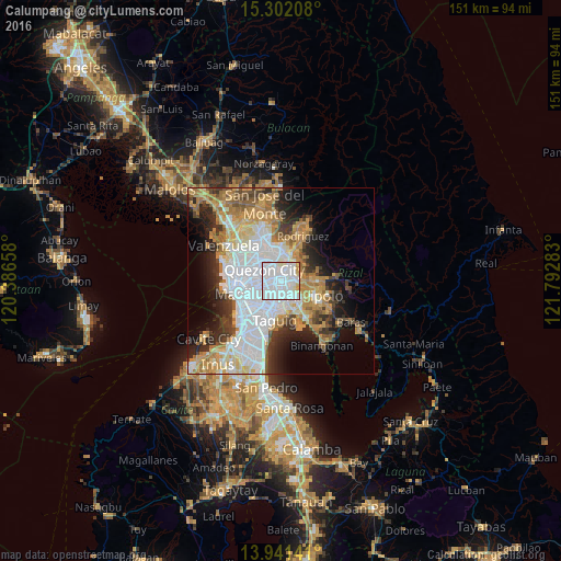
Analysis of Calumpang night lights 2016
Square area 10x10 km:
 69.26%
90-99
23.81%80-89
3.9%70-79
3.03%60-69
0%50-59
0%40-49
0%30-39
0%20-29
0%10-19
0%0-9
0%Square area 50x50 km:
14.11%90-99
8.17%80-89
4.6%70-79
7.27%60-69
6.82%50-59
2.8%40-49
3.23%30-39
4.96%20-29
6.67%10-19
8.2%0-9
33.18%Clear (daylight) street map image can be seen on geolist.org.
Map coordinates:
15° 18' 7.5" North, 120° 23' 11.7" East
14° 37' 22.1" North, 121° 5' 22.9" East
13° 56' 29.1" North, 121° 47' 34.2" East
Some cities around Calumpang sort by population:
• Quezon City
5.1 km =3.2 mi,  304°
304°
• Pasig City
5 km =3.1 mi,  217°
217°
• Antipolo
3.5 km =2.2 mi,  84°
84°
• Mandaluyong City
6.9 km =4.3 mi,  230°
230°
• Cainta
6 km =3.7 mi,  144°
144°
• San Juan
6.6 km =4.1 mi,  247°
247°
• Bagong Pagasa
7.6 km =4.7 mi,  305°
305°
• Del Monte
8 km =5 mi,  285°
285°
1720052 (p: 15,589)
Sources (retrieved 2019-11-25):
» Earth at Night: Flat Maps 2012, 2016