Cabano night lights from space
Night Light of Cabano (Western Visayas) from space (Philippines) Src. Average luminocity for 10x10km area is 0.343% and for 50x50km: 5.6274%.
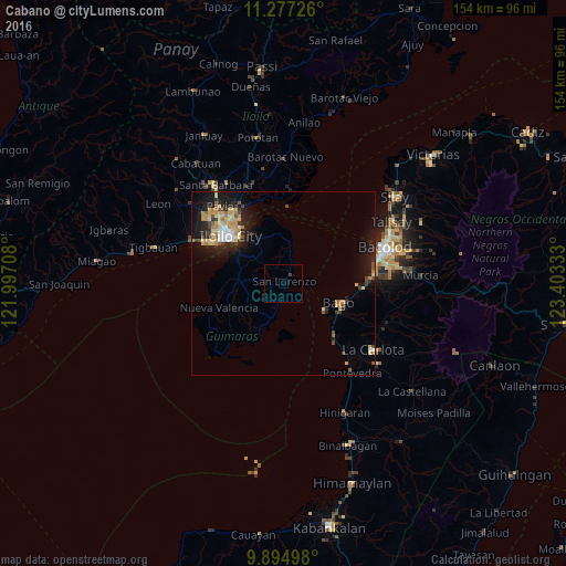
Analysis of Cabano night lights 2016
Square area 10x10 km:
 0%
0%90-99
0%80-89
0%70-79
0%60-69
0%50-59
0%40-49
0.83%30-39
0%20-29
0%10-19
0%0-9
99.17%Square area 50x50 km:
0.38%90-99
0.5%80-89
1.39%70-79
1.15%60-69
0.48%50-59
0.4%40-49
0.8%30-39
0.64%20-29
1.71%10-19
5.08%0-9
87.48%Clear (daylight) street map image can be seen on geolist.org.
Map coordinates:
11° 16' 38.1" North, 121° 59' 49.5" East
10° 35' 12.8" North, 122° 42' 0.7" East
9° 53' 41.9" North, 123° 24' 12" East
Some cities around Cabano sort by population:
• Iloilo
19.2 km =11.9 mi,  309°
309°
• Bago City
15.7 km =9.8 mi,  112°
112°
• Pulupandan
13.3 km =8.3 mi,  123°
123°
• Taloc
21.4 km =13.3 mi,  93°
93°
• Pacol
19.8 km =12.3 mi,  140°
140°
• Jordan
13.9 km =8.6 mi,  304°
304°
• Salvacion
14.1 km =8.8 mi,  319°
319°
• Busay
21 km =13 mi, 105°
1721842 (p: 5,812)
Sources (retrieved 2019-11-25):
» Earth at Night: Flat Maps 2012, 2016