Bahay Pare night lights from space
Night Light of Bahay Pare (Central Luzon) from space (Philippines) Src. Average luminocity for 10x10km area is 2.9525% and for 50x50km: 15.7206%.
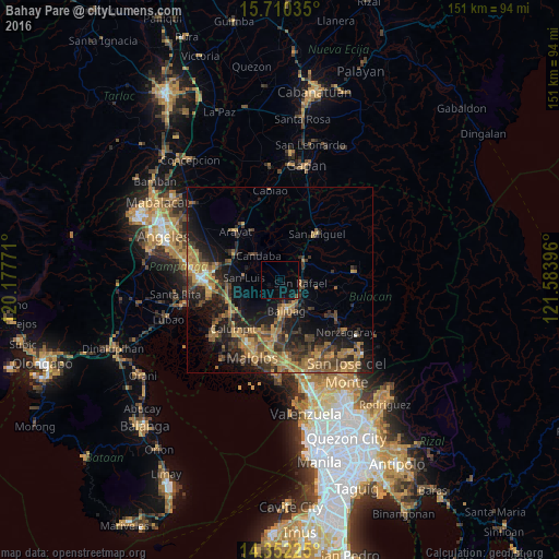
Analysis of Bahay Pare night lights 2016
Square area 10x10 km:
 0%
0%90-99
0%80-89
0%70-79
0%60-69
0.21%50-59
0.21%40-49
0.83%30-39
0%20-29
0.41%10-19
3.93%0-9
94.42%Square area 50x50 km:
0.27%90-99
0.41%80-89
0.97%70-79
4.13%60-69
4.62%50-59
2.5%40-49
3.89%30-39
4.16%20-29
5.36%10-19
10.79%0-9
62.91%Clear (daylight) street map image can be seen on geolist.org.
Map coordinates:
15° 42' 37.3" North, 120° 10' 39.8" East
15° 1' 56.6" North, 120° 52' 51" East
14° 21' 8.1" North, 121° 35' 2.3" East
Some cities around Bahay Pare sort by population:
• Baliuag
8.8 km =5.5 mi,  168°
168°
• San Ildefonso
8.4 km =5.2 mi,  50°
50°
• Candaba
9.1 km =5.7 mi,  320°
320°
• Bustos
9.2 km =5.7 mi,  154°
154°
• Pantubig
10.7 km =6.6 mi,  132°
132°
• San Luis
10 km =6.2 mi,  274°
274°
• San Jose
10.5 km =6.5 mi, 270°
• San Isidro
6.6 km =4.1 mi,  259°
259°
1728830 (p: 9,726)
Sources (retrieved 2019-11-25):
» Earth at Night: Flat Maps 2012, 2016