Aritao night lights from space
Night Light of Aritao (Cagayan Valley) from space (Philippines) Src. Average luminocity for 10x10km area is 0.4566% and for 50x50km: 0.2391%.
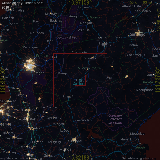
Analysis of Aritao night lights 2016
Square area 10x10 km:
 0%
0%90-99
0%80-89
0%70-79
0%60-69
0%50-59
0%40-49
0%30-39
0%20-29
0.83%10-19
0.83%0-9
98.35%Square area 50x50 km:
0%90-99
0%80-89
0%70-79
0.07%60-69
0.03%50-59
0.01%40-49
0.16%30-39
0.07%20-29
0.09%10-19
0.13%0-9
99.44%Clear (daylight) street map image can be seen on geolist.org.
Map coordinates:
16° 58' 17.7" North, 120° 19' 53" East
16° 17' 52.4" North, 121° 2' 4.2" East
15° 37' 18.8" North, 121° 44' 15.5" East
Some cities around Aritao sort by population:
• Bayombong
23.8 km =14.8 mi,  31°
31°
• Solano
29.2 km =18.1 mi, 32°
• Baggabag B
28.5 km =17.7 mi,  35°
35°
• Bambang
12.5 km =7.8 mi, 37°
• Carranglan
37.6 km =23.4 mi,  175°
175°
• Bone South
7.2 km =4.5 mi,  214°
214°
• Natividad
37.8 km =23.5 mi,  221°
221°
• Quezon
33.4 km =20.8 mi,  47°
47°
1730162 (p: 7,971)
Sources (retrieved 2019-11-25):
» Earth at Night: Flat Maps 2012, 2016