Mala night lights from space
Night Light of Mala (Lima region) from space (Peru) Src. Average luminocity for 10x10km area is 23.3636% and for 50x50km: 6.5622%.
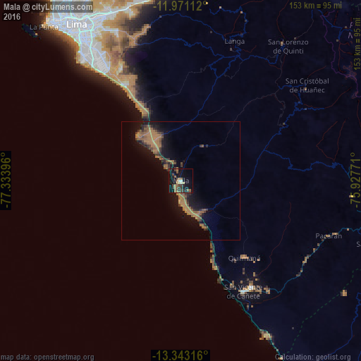
Analysis of Mala night lights 2016
Square area 10x10 km:
 0.65%
0.65%90-99
1.95%80-89
1.73%70-79
1.08%60-69
7.79%50-59
4.11%40-49
6.49%30-39
5.41%20-29
3.68%10-19
25.97%0-9
41.13%Square area 50x50 km:
0.03%90-99
0.08%80-89
0.1%70-79
0.19%60-69
3.76%50-59
1.76%40-49
1.13%30-39
1.26%20-29
1.2%10-19
6.35%0-9
84.16%Clear (daylight) street map image can be seen on geolist.org.
Map coordinates:
11° 58' 16" South, 77° 20' 2.3" West
12° 39' 29" South, 76° 37' 51" West
13° 20' 35.4" South, 75° 55' 39.8" West
Some cities around Mala sort by population:
• Santiago de Surco
71 km =44.1 mi,  324°
324°
• San Isidro
75.5 km =46.9 mi, 322°
• Nuevo Imperial
57.5 km =35.7 mi,  143°
143°
• Imperial
53.8 km =33.4 mi,  145°
145°
• San Vicente de Cañete
53.5 km =33.2 mi, 150°
• Chilca
19.1 km =11.9 mi, 322°
• Quilmaná
42.2 km =26.2 mi, 140°
• San Bartolo
34.7 km =21.6 mi,  331°
331°
3935572 (p: 17,260)
Sources (retrieved 2019-11-25):
» Earth at Night: Flat Maps 2012, 2016