Chilca night lights from space
Night Light of Chilca (Lima region) from space (Peru) Src. Average luminocity for 10x10km area is 42.961% and for 50x50km: 7.3895%.
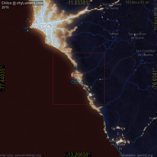
Analysis of Chilca night lights 2016
Square area 10x10 km:
 0%
0%90-99
0%80-89
0%70-79
1.3%60-69
39.83%50-59
9.09%40-49
8.44%30-39
6.06%20-29
6.06%10-19
24.46%0-9
4.76%Square area 50x50 km:
0.06%90-99
0.08%80-89
0.17%70-79
0.29%60-69
4.18%50-59
1.65%40-49
1.05%30-39
1.44%20-29
1.82%10-19
8.02%0-9
81.25%Clear (daylight) street map image can be seen on geolist.org.
Map coordinates:
11° 50' 1.7" South, 77° 26' 25.3" West
12° 31' 16" South, 76° 44' 14" West
13° 12' 23.7" South, 76° 2' 2.8" West
Some cities around Chilca sort by population:
• Lima
61.8 km =38.4 mi,  329°
329°
• Santiago de Surco
51.9 km =32.2 mi, 325°
• San Isidro
56.4 km =35 mi,  322°
322°
• Mala
19.1 km =11.9 mi,  142°
142°
• Santa María
59.8 km =37.2 mi,  343°
343°
• San Luis
56.8 km =35.3 mi, 330°
• Quilmaná
61.2 km =38 mi, 140°
• San Bartolo
16.1 km =10 mi, 341°
3943957 (p: 12,884)
Sources (retrieved 2019-11-25):
» Earth at Night: Flat Maps 2012, 2016