Ski night lights from space
Night Light of Ski (Akershus) from space (Norway) Src. Average luminocity for 10x10km area is 35.9773% and for 50x50km: 21.2535%.
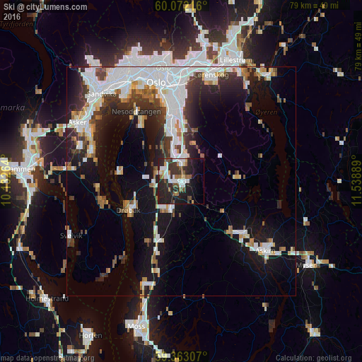
Analysis of Ski night lights 2016
Square area 10x10 km:
100  7.25%
7.25%
90-99 7.25%
80-89 1.95%
70-79 2.27%
60-69 4.11%
50-59 5.74%
40-49 3.25%
30-39 7.25%
20-29 21.86%
10-19 19.05%
0-9 20.02%
7.25%90-99
7.25%80-89
1.95%70-79
2.27%60-69
4.11%50-59
5.74%40-49
3.25%30-39
7.25%20-29
21.86%10-19
19.05%0-9
20.02%Square area 50x50 km:
100 6.31%
90-99 4.69%
80-89 1.39%
70-79 1.56%
60-69 1.74%
50-59 1.83%
40-49 1.81%
30-39 3.02%
20-29 5%
10-19 12.03%
0-9 60.62%
6.31%90-99
4.69%80-89
1.39%70-79
1.56%60-69
1.74%50-59
1.83%40-49
1.81%30-39
3.02%20-29
5%10-19
12.03%0-9
60.62%Clear (daylight) street map image can be seen on geolist.org.
Map coordinates:
60° 4' 19.8" North, 10° 7' 57.5" East
59° 43' 10.2" North, 10° 50' 8.7" East
59° 21' 47.1" North, 11° 32' 20" East
Some cities around Ski sort by population:
• Oslo
22.1 km =13.7 mi,  346°
346°
• Asker
25.6 km =15.9 mi,  299°
299°
• Lillestrøm
28.9 km =18 mi,  24°
24°
• Askim
23.8 km =14.8 mi,  129°
129°
• Drøbak
13.1 km =8.1 mi,  241°
241°
• Nesoddtangen
18.6 km =11.6 mi,  328°
328°
• Ås
6.5 km =4 mi,  200°
200°
• Vestby
13.6 km =8.5 mi, 200°
3139081 (p: 12,513)
Sources (retrieved 2019-11-25):
» Earth at Night: Flat Maps 2012, 2016