Vestby night lights from space
Night Light of Vestby (Akershus) from space (Norway) Src. Average luminocity for 10x10km area is 16.6485% and for 50x50km: 13.4538%.
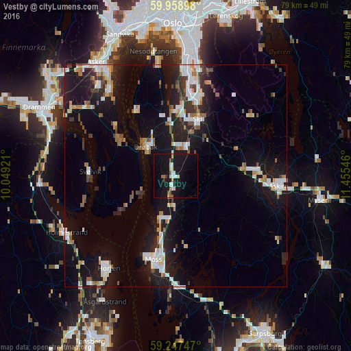
Analysis of Vestby night lights 2016
Square area 10x10 km:
100  3.4%
3.4%
90-99 2.15%
80-89 1.25%
70-79 0.91%
60-69 2.27%
50-59 1.59%
40-49 0.45%
30-39 0.45%
20-29 0%
10-19 34.47%
0-9 53.06%
3.4%90-99
2.15%80-89
1.25%70-79
0.91%60-69
2.27%50-59
1.59%40-49
0.45%30-39
0.45%20-29
0%10-19
34.47%0-9
53.06%Square area 50x50 km:
100 2.44%
90-99 2.62%
80-89 1.02%
70-79 1.21%
60-69 1.35%
50-59 1.42%
40-49 1.37%
30-39 1.35%
20-29 3.38%
10-19 13.47%
0-9 70.38%
2.44%90-99
2.62%80-89
1.02%70-79
1.21%60-69
1.35%50-59
1.42%40-49
1.37%30-39
1.35%20-29
3.38%10-19
13.47%0-9
70.38%Clear (daylight) street map image can be seen on geolist.org.
Map coordinates:
59° 57' 32.3" North, 10° 2' 57.2" East
59° 36' 18.4" North, 10° 45' 8.4" East
59° 14' 50.9" North, 11° 27' 19.7" East
Some cities around Vestby sort by population:
• Moss
19.8 km =12.3 mi,  195°
195°
• Horten
25.8 km =16 mi,  215°
215°
• Ski
13.6 km =8.5 mi,  20°
20°
• Askim
23.2 km =14.4 mi,  96°
96°
• Drøbak
9.5 km =5.9 mi,  313°
313°
• Nesoddtangen
29 km =18 mi,  350°
350°
• Ås
7 km =4.3 mi, 19°
• Holmestrand
27.8 km =17.3 mi,  241°
241°
3132058 (p: 5,330)
Sources (retrieved 2019-11-25):
» Earth at Night: Flat Maps 2012, 2016