Zelhem night lights from space
Night Light of Zelhem (Gelderland) from space (Netherlands) Src. Average luminocity for 10x10km area is 11.25% and for 50x50km: 9.9404%.
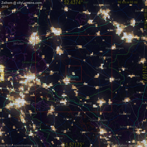
Analysis of Zelhem night lights 2016
Square area 10x10 km:
 1.39%
1.39%90-99
1.64%80-89
1.52%70-79
1.01%60-69
1.77%50-59
1.89%40-49
1.64%30-39
0.38%20-29
0.51%10-19
11.62%0-9
76.64%Square area 50x50 km:
0.81%90-99
1.37%80-89
0.92%70-79
1.05%60-69
1.56%50-59
1.73%40-49
1.3%30-39
0.76%20-29
1.49%10-19
9.84%0-9
79.17%Clear (daylight) street map image can be seen on geolist.org.
Map coordinates:
52° 26' 14.6" North, 5° 38' 43.8" East
52° 0' 24" North, 6° 20' 55" East
51° 34' 18.3" North, 7° 3' 6.3" East
Some cities around Zelhem sort by population:
• Doetinchem
6.2 km =3.9 mi,  221°
221°
• Brummen
16.1 km =10 mi,  305°
305°
• Lichtenvoorde
15.1 km =9.4 mi,  98°
98°
• Wisch
10.1 km =6.3 mi,  152°
152°
• Doesburg
14.4 km =8.9 mi,  272°
272°
• Leesten
15.7 km =9.8 mi,  329°
329°
• Ruurlo
11.4 km =7.1 mi,  37°
37°
• Varsseveld
10.3 km =6.4 mi,  133°
133°
2743963 (p: 5,760)
Sources (retrieved 2019-11-25):
» Earth at Night: Flat Maps 2012, 2016