Lichtenvoorde night lights from space
Night Light of Lichtenvoorde (Gelderland) from space (Netherlands) Src. Average luminocity for 10x10km area is 6.5505% and for 50x50km: 7.9437%.
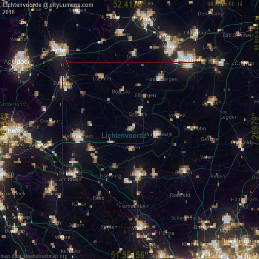
Analysis of Lichtenvoorde night lights 2016
Square area 10x10 km:
 0.13%
0.13%90-99
0.88%80-89
1.01%70-79
1.52%60-69
1.01%50-59
0%40-49
0.51%30-39
0.88%20-29
0.13%10-19
0.25%0-9
93.69%Square area 50x50 km:
0.73%90-99
1.17%80-89
0.6%70-79
0.92%60-69
1.26%50-59
1.44%40-49
1.09%30-39
0.52%20-29
1.04%10-19
6.47%0-9
84.76%Clear (daylight) street map image can be seen on geolist.org.
Map coordinates:
52° 25' 3.4" North, 5° 51' 48.7" East
51° 59' 12" North, 6° 34' 0" East
51° 33' 5.6" North, 7° 16' 11.2" East
Some cities around Lichtenvoorde sort by population:
• Winterswijk
10.6 km =6.6 mi,  98°
98°
• Wisch
12.2 km =7.6 mi,  236°
236°
• Aalten
6.9 km =4.3 mi,  172°
172°
• Eibergen
13.8 km =8.6 mi,  23°
23°
• Borculo
14.7 km =9.1 mi,  348°
348°
• Ruurlo
13.8 km =8.6 mi,  324°
324°
• Zelhem
15.1 km =9.4 mi,  278°
278°
• Varsseveld
8.8 km =5.5 mi, 237°
2751651 (p: 19,590)
Sources (retrieved 2019-11-25):
» Earth at Night: Flat Maps 2012, 2016