Varsseveld night lights from space
Night Light of Varsseveld (Gelderland) from space (Netherlands) Src. Average luminocity for 10x10km area is 4.0379% and for 50x50km: 8.4042%.
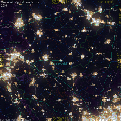
Analysis of Varsseveld night lights 2016
Square area 10x10 km:
 0.38%
0.38%90-99
0.51%80-89
0.63%70-79
0%60-69
1.26%50-59
0%40-49
0%30-39
1.01%20-29
0.13%10-19
0.13%0-9
95.96%Square area 50x50 km:
0.72%90-99
1.21%80-89
0.68%70-79
0.93%60-69
1.37%50-59
1.55%40-49
1.27%30-39
0.63%20-29
0.89%10-19
6.29%0-9
84.46%Clear (daylight) street map image can be seen on geolist.org.
Map coordinates:
52° 22' 28.8" North, 5° 45' 18.7" East
51° 56' 36" North, 6° 27' 30" East
51° 30' 28.1" North, 7° 9' 41.2" East
Some cities around Varsseveld sort by population:
• Bocholt, DE
15.8 km =9.8 mi,  137°
137°
• Doetinchem
11.9 km =7.4 mi,  281°
281°
• Lichtenvoorde
8.8 km =5.5 mi,  57°
57°
• Wisch
3.4 km =2.1 mi,  236°
236°
• Aalten
8.6 km =5.3 mi,  103°
103°
• Isselburg, DE
12.3 km =7.6 mi,  178°
178°
• Ruurlo
16.1 km =10 mi,  357°
357°
• Zelhem
10.3 km =6.4 mi,  313°
313°
2745800 (p: 5,450)
Sources (retrieved 2019-11-25):
» Earth at Night: Flat Maps 2012, 2016