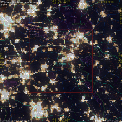
Wijchen night lights from space
Night Light of Wijchen (Gelderland) from space (Netherlands) Src. Average luminocity for 10x10km area is 28.8137% and for 50x50km: 22.065%.
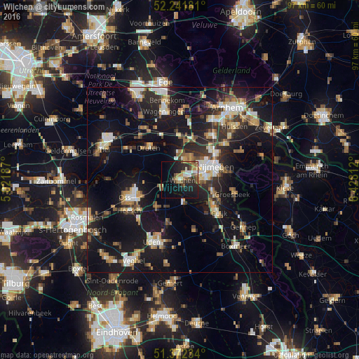
Analysis of Wijchen night lights 2016
Square area 10x10 km:
100  3.22%
3.22%
90-99 3.5%
80-89 2.8%
70-79 3.22%
60-69 5.04%
50-59 6.16%
40-49 3.78%
30-39 3.64%
20-29 12.32%
10-19 23.95%
0-9 32.35%
3.22%90-99
3.5%80-89
2.8%70-79
3.22%60-69
5.04%50-59
6.16%40-49
3.78%30-39
3.64%20-29
12.32%10-19
23.95%0-9
32.35%Square area 50x50 km:
100 2.7%
90-99 3.48%
80-89 2.26%
70-79 2.37%
60-69 3.11%
50-59 2.85%
40-49 2.54%
30-39 3.31%
20-29 6.76%
10-19 23.39%
0-9 47.23%
2.7%90-99
3.48%80-89
2.26%70-79
2.37%60-69
3.11%50-59
2.85%40-49
2.54%30-39
3.31%20-29
6.76%10-19
23.39%0-9
47.23%Clear (daylight) street map image can be seen on geolist.org.
Map coordinates:
52° 14' 30.5" North, 5° 1' 18.7" East
51° 48' 33" North, 5° 43' 30" East
51° 22' 20.4" North, 6° 25' 41.2" East
Some cities around Wijchen sort by population:
• Nijmegen
9.5 km =5.9 mi,  67°
67°
• Beuningen
6.4 km =4 mi,  26°
26°
• Lindenholt
5.4 km =3.4 mi,  60°
60°
• Grave
5.7 km =3.5 mi,  170°
170°
• Hatert
7.3 km =4.5 mi,  92°
92°
• Lent
11.3 km =7 mi, 59°
• Hengstdal
11.2 km =7 mi,  76°
76°
• Schaijk
9.5 km =5.9 mi,  222°
222°
2744514 (p: 32,693)
Sources (retrieved 2019-11-25):
» Earth at Night: Flat Maps 2012, 2016