Schaijk night lights from space
Night Light of Schaijk (North Brabant) from space (Netherlands) Src. Average luminocity for 10x10km area is 16.8683% and for 50x50km: 22.794%.
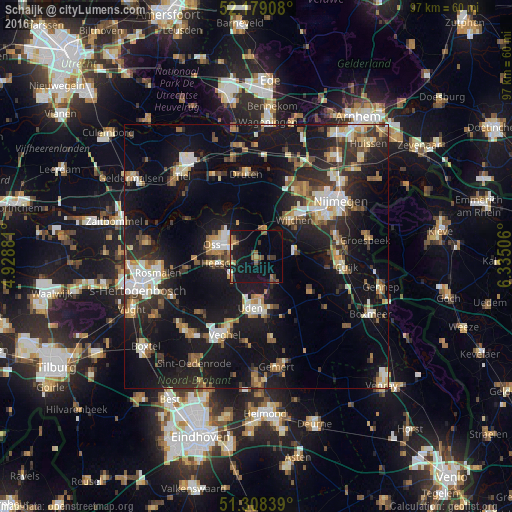
Analysis of Schaijk night lights 2016
Square area 10x10 km:
100  0%
0%
90-99 1.12%
80-89 0.56%
70-79 2.66%
60-69 2.8%
50-59 4.34%
40-49 1.68%
30-39 2.52%
20-29 3.78%
10-19 30.67%
0-9 49.86%
0%90-99
1.12%80-89
0.56%70-79
2.66%60-69
2.8%50-59
4.34%40-49
1.68%30-39
2.52%20-29
3.78%10-19
30.67%0-9
49.86%Square area 50x50 km:
100 2.77%
90-99 3.47%
80-89 2.24%
70-79 2.51%
60-69 3.1%
50-59 3.02%
40-49 2.62%
30-39 3.57%
20-29 6.83%
10-19 25.19%
0-9 44.66%
2.77%90-99
3.47%80-89
2.24%70-79
2.51%60-69
3.1%50-59
3.02%40-49
2.62%30-39
3.57%20-29
6.83%10-19
25.19%0-9
44.66%Clear (daylight) street map image can be seen on geolist.org.
Map coordinates:
52° 10' 44.7" North, 4° 55' 43.7" East
51° 44' 45" North, 5° 37' 55" East
51° 18' 30.2" North, 6° 20' 6.2" East
Some cities around Schaijk sort by population:
• Oss
8.1 km =5 mi,  285°
285°
• Uden
9.5 km =5.9 mi,  185°
185°
• Wijchen
9.5 km =5.9 mi,  42°
42°
• Lindenholt
14.7 km =9.1 mi,  48°
48°
• Grave
7.5 km =4.7 mi,  78°
78°
• Heesch
7.4 km =4.6 mi,  259°
259°
• Berghem
5.1 km =3.2 mi,  301°
301°
• Nistelrode
6.7 km =4.2 mi,  225°
225°
2747713 (p: 5,970)
Sources (retrieved 2019-11-25):
» Earth at Night: Flat Maps 2012, 2016