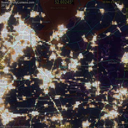
Soest night lights from space
Night Light of Soest (Utrecht) from space (Netherlands) Src. Average luminocity for 10x10km area is 33.2262% and for 50x50km: 29.9278%.
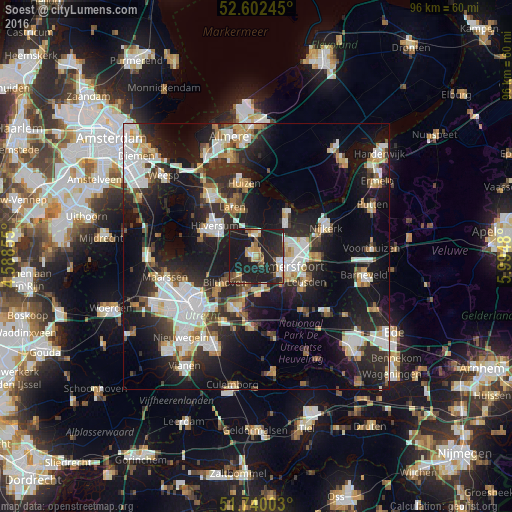
Analysis of Soest night lights 2016
Square area 10x10 km:
100  2.51%
2.51%
90-99 3.97%
80-89 3.57%
70-79 4.89%
60-69 3.57%
50-59 3.44%
40-49 4.5%
30-39 2.78%
20-29 24.87%
10-19 45.9%
0-9 0%
2.51%90-99
3.97%80-89
3.57%70-79
4.89%60-69
3.57%50-59
3.44%40-49
4.5%30-39
2.78%20-29
24.87%10-19
45.9%0-9
0%Square area 50x50 km:
100 6.35%
90-99 6%
80-89 2.58%
70-79 2.94%
60-69 3.07%
50-59 2.62%
40-49 3.1%
30-39 3.73%
20-29 11.03%
10-19 23.3%
0-9 35.3%
6.35%90-99
6%80-89
2.58%70-79
2.94%60-69
3.07%50-59
2.62%40-49
3.1%30-39
3.73%20-29
11.03%10-19
23.3%0-9
35.3%Clear (daylight) street map image can be seen on geolist.org.
Map coordinates:
52° 36' 8.8" North, 4° 35' 18.8" East
52° 10' 24" North, 5° 17' 30" East
51° 44' 24.1" North, 5° 59' 41.3" East
Some cities around Soest sort by population:
• Amersfoort
6.8 km =4.2 mi,  107°
107°
• Hilversum
9.6 km =6 mi,  305°
305°
• Zeist
10.1 km =6.3 mi,  203°
203°
• Baarn
4.3 km =2.7 mi,  356°
356°
• Laren
10.2 km =6.3 mi,  334°
334°
• Hoogland
5.7 km =3.5 mi,  79°
79°
• De Bilt
10.3 km =6.4 mi,  227°
227°
• Randenbroek
8 km =5 mi, 110°
2747034 (p: 45,021)
Sources (retrieved 2019-11-25):
» Earth at Night: Flat Maps 2012, 2016