Sint-Oedenrode night lights from space
Night Light of Sint-Oedenrode (North Brabant) from space (Netherlands) Src. Average luminocity for 10x10km area is 25.2527% and for 50x50km: 25.9374%.
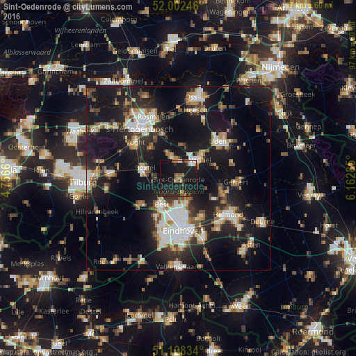
Analysis of Sint-Oedenrode night lights 2016
Square area 10x10 km:
 2.14%
2.14%90-99
2.41%80-89
0.53%70-79
2.67%60-69
3.21%50-59
4.41%40-49
3.34%30-39
1.6%20-29
14.97%10-19
51.87%0-9
12.83%Square area 50x50 km:
3.99%90-99
4.63%80-89
2.22%70-79
2.83%60-69
3.26%50-59
3.33%40-49
2.72%30-39
3.53%20-29
8.31%10-19
26.91%0-9
38.29%Clear (daylight) street map image can be seen on geolist.org.
Map coordinates:
52° 0' 8.9" North, 4° 45' 23.8" East
51° 34' 3" North, 5° 27' 35" East
51° 7' 42" North, 6° 9' 46.3" East
Some cities around Sint-Oedenrode sort by population:
• Boxtel
9.4 km =5.8 mi,  286°
286°
• Best
8.2 km =5.1 mi,  215°
215°
• Veghel
8.2 km =5.1 mi,  48°
48°
• Schijndel
6.4 km =4 mi,  342°
342°
• Oirschot
12.2 km =7.6 mi,  235°
235°
• Heeswijk-Dinther
9.3 km =5.8 mi,  6°
6°
• Woenselse Heide
9.4 km =5.8 mi,  177°
177°
• Vaartbroek
10.1 km =6.3 mi,  164°
164°
2747227 (p: 16,931)
Sources (retrieved 2019-11-25):
» Earth at Night: Flat Maps 2012, 2016