Oirschot night lights from space
Night Light of Oirschot (North Brabant) from space (Netherlands) Src. Average luminocity for 10x10km area is 18.6176% and for 50x50km: 26.8236%.
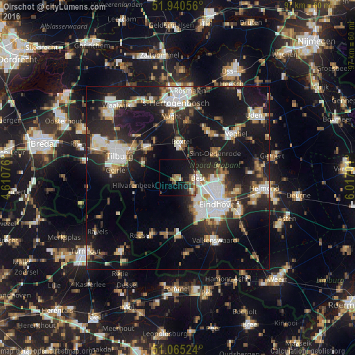
Analysis of Oirschot night lights 2016
Square area 10x10 km:
 1.2%
1.2%90-99
1.47%80-89
1.6%70-79
2.14%60-69
3.21%50-59
5.61%40-49
3.34%30-39
0.94%20-29
4.68%10-19
24.2%0-9
51.6%Square area 50x50 km:
4.71%90-99
5.41%80-89
2.41%70-79
2.51%60-69
2.97%50-59
3.12%40-49
2.53%30-39
3.6%20-29
9.03%10-19
23.76%0-9
39.95%Clear (daylight) street map image can be seen on geolist.org.
Map coordinates:
51° 56' 26" North, 4° 36' 38.7" East
51° 30' 18" North, 5° 18' 50" East
51° 3' 54.9" North, 6° 1' 1.2" East
Some cities around Oirschot sort by population:
• Boxtel
9.6 km =6 mi,  6°
6°
• Best
5.3 km =3.3 mi,  86°
86°
• Oisterwijk
11.9 km =7.4 mi,  313°
313°
• Meerhoven
9.7 km =6 mi,  135°
135°
• Grasrijk
10.2 km =6.3 mi, 136°
• Veldhoven
11.4 km =7.1 mi,  147°
147°
• Zeelst
11.4 km =7.1 mi, 141°
• Woenselse Heide
10.8 km =6.7 mi,  102°
102°
2749683 (p: 10,393)
Sources (retrieved 2019-11-25):
» Earth at Night: Flat Maps 2012, 2016