Meijel night lights from space
Night Light of Meijel (Limburg) from space (Netherlands) Src. Average luminocity for 10x10km area is 1.6807% and for 50x50km: 16.1225%.
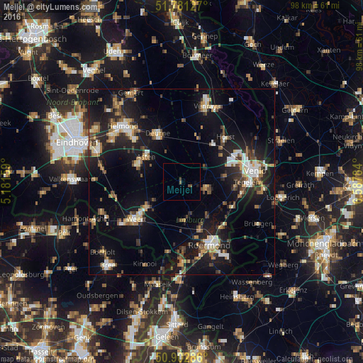
Analysis of Meijel night lights 2016
Square area 10x10 km:
 0%
0%90-99
0%80-89
0%70-79
0%60-69
0%50-59
0.84%40-49
1.26%30-39
0.14%20-29
0.28%10-19
0.56%0-9
96.92%Square area 50x50 km:
1.73%90-99
2.25%80-89
1.64%70-79
1.62%60-69
1.87%50-59
2.58%40-49
2.37%30-39
2.23%20-29
5.06%10-19
15.77%0-9
62.89%Clear (daylight) street map image can be seen on geolist.org.
Map coordinates:
51° 46' 52.6" North, 5° 10' 53.7" East
51° 20' 39" North, 5° 53' 5" East
50° 54' 10.3" North, 6° 35' 16.2" East
Some cities around Meijel sort by population:
• Someren
12.9 km =8 mi,  290°
290°
• Asten
11.6 km =7.2 mi,  305°
305°
• Nederweert
11.5 km =7.1 mi,  235°
235°
• Panningen
6.8 km =4.2 mi,  106°
106°
• Heythuysen
10.5 km =6.5 mi,  174°
174°
• Helden
8.5 km =5.3 mi, 109°
• Maasbree
11.5 km =7.1 mi,  82°
82°
• Sevenum
13 km =8.1 mi,  54°
54°
2750995 (p: 5,180)
Sources (retrieved 2019-11-25):
» Earth at Night: Flat Maps 2012, 2016