Maasbree night lights from space
Night Light of Maasbree (Limburg) from space (Netherlands) Src. Average luminocity for 10x10km area is 24.3193% and for 50x50km: 14.2118%.
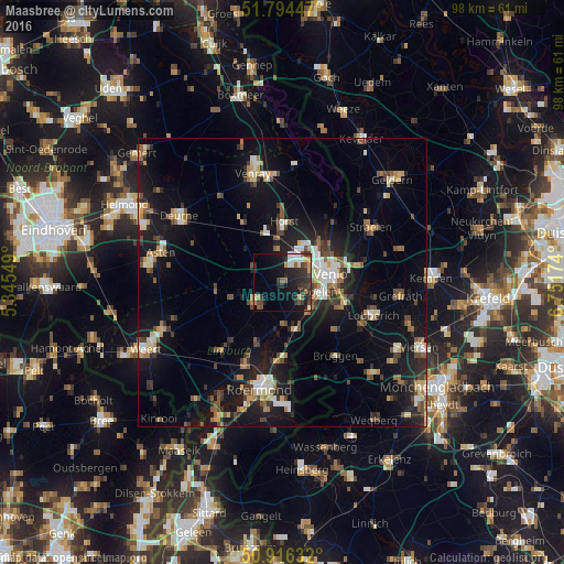
Analysis of Maasbree night lights 2016
Square area 10x10 km:
100  2.8%
2.8%
90-99 3.08%
80-89 1.96%
70-79 3.36%
60-69 0.42%
50-59 3.36%
40-49 4.34%
30-39 8.96%
20-29 11.2%
10-19 18.49%
0-9 42.02%
2.8%90-99
3.08%80-89
1.96%70-79
3.36%60-69
0.42%50-59
3.36%40-49
4.34%30-39
8.96%20-29
11.2%10-19
18.49%0-9
42.02%Square area 50x50 km:
100 1.42%
90-99 1.99%
80-89 1.46%
70-79 1.5%
60-69 1.44%
50-59 2.28%
40-49 2.44%
30-39 1.89%
20-29 3.9%
10-19 13.49%
0-9 68.2%
1.42%90-99
1.99%80-89
1.46%70-79
1.5%60-69
1.44%50-59
2.28%40-49
2.44%30-39
1.89%20-29
3.9%10-19
13.49%0-9
68.2%Clear (daylight) street map image can be seen on geolist.org.
Map coordinates:
51° 47' 40.1" North, 5° 20' 43.8" East
51° 21' 27" North, 6° 2' 55" East
50° 54' 58.8" North, 6° 45' 6.3" East
Some cities around Maasbree sort by population:
• Venlo
8.4 km =5.2 mi,  80°
80°
• Tegelen
6.3 km =3.9 mi,  103°
103°
• Panningen
5.9 km =3.7 mi,  234°
234°
• Reuver
8.4 km =5.2 mi,  166°
166°
• Helden
5.4 km =3.4 mi,  218°
218°
• Baarlo
4.4 km =2.7 mi,  132°
132°
• Meijel
11.5 km =7.1 mi,  262°
262°
• Sevenum
6.2 km =3.9 mi,  352°
352°
2751301 (p: 5,045)
Sources (retrieved 2019-11-25):
» Earth at Night: Flat Maps 2012, 2016