Panningen night lights from space
Night Light of Panningen (Limburg) from space (Netherlands) Src. Average luminocity for 10x10km area is 7.8067% and for 50x50km: 15.0785%.
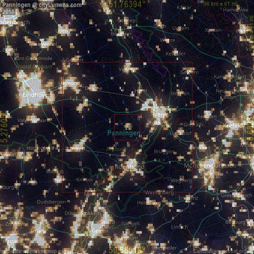
Analysis of Panningen night lights 2016
Square area 10x10 km:
100  0%
0%
90-99 0%
80-89 0.56%
70-79 1.12%
60-69 1.12%
50-59 1.4%
40-49 3.64%
30-39 1.12%
20-29 1.4%
10-19 1.68%
0-9 87.96%
0%90-99
0%80-89
0.56%70-79
1.12%60-69
1.12%50-59
1.4%40-49
3.64%30-39
1.12%20-29
1.4%10-19
1.68%0-9
87.96%Square area 50x50 km:
100 1.61%
90-99 2.09%
80-89 1.64%
70-79 1.59%
60-69 1.46%
50-59 2.34%
40-49 2.48%
30-39 2.15%
20-29 4.05%
10-19 13.94%
0-9 66.65%
1.61%90-99
2.09%80-89
1.64%70-79
1.59%60-69
1.46%50-59
2.34%40-49
2.48%30-39
2.15%20-29
4.05%10-19
13.94%0-9
66.65%Clear (daylight) street map image can be seen on geolist.org.
Map coordinates:
51° 45' 50.2" North, 5° 16' 33.8" East
51° 19' 36" North, 5° 58' 45" East
50° 53' 6.7" North, 6° 40' 56.3" East
Some cities around Panningen sort by population:
• Haelen
10.2 km =6.3 mi,  188°
188°
• Heythuysen
10.2 km =6.3 mi,  213°
213°
• Reuver
8.3 km =5.2 mi,  124°
124°
• Helden
1.7 km =1.1 mi, 119°
• Baarlo
8 km =5 mi,  86°
86°
• Meijel
6.8 km =4.2 mi,  286°
286°
• Maasbree
5.9 km =3.7 mi,  54°
54°
• Sevenum
10.4 km =6.5 mi,  22°
22°
2748737 (p: 6,710)
Sources (retrieved 2019-11-25):
» Earth at Night: Flat Maps 2012, 2016